Scientists Just Rewrote How Ocean Currents Work — Here’s Why Your Coastal Property Should Care
The ocean doesn’t care about your closing date.
That’s the thing they don’t tell you in the listing. They’ll tell you about the view. The light. How the water looks in the morning when the fog sits low over the Sound. Nobody hands you a brochure about the Atlantic Meridional Overturning Circulation and what happens to your flood insurance when it starts to go.
This is that brochure.
In 2023, a pair of Danish climate scientists — Peter Ditlevsen and Susanne Ditlevsen, writing in Nature Communications — published a statistical analysis of Atlantic Ocean temperature records going back to 1870. What they found wasn’t a slow, gradual warming story. It was something closer to a tipping point signal. The kind of thing that, once it tips, doesn’t tip back.
Most people read it and moved on. The people who sell coastal real estate definitely moved on. That was a mistake.
What the New AMOC Research Actually Found
AMOC — the Atlantic Meridional Overturning Circulation — is the ocean’s conveyor belt. Cold, dense, salty water sinks in the North Atlantic and drives a circulation system that moves heat from the tropics toward Europe and the northeastern United States. It’s why London isn’t as cold as Labrador. It’s why the Gulf Stream is the Gulf Stream.
The Ditlevsen analysis applied early-warning statistical methods — specifically, indicators of “critical slowing down,” a fingerprint that complex systems emit before they collapse — to 150 years of ocean data. Their conclusion: AMOC may be approaching a tipping point, potentially within this century. Scientists from the University of Copenhagen warned that the system could cease to function between 2025 and 2095, with some models centering the collapse risk around mid-century.
Other climate scientists have pushed back on the methodology. The debate is real. But the debate is now the mainstream scientific conversation. The question is no longer whether AMOC is slowing — satellite and oceanographic data confirm it has weakened measurably, by approximately 15% over the past century — but how fast, and what happens when the slowdown crosses a threshold.
Writing in The Invading Sea, Marc Alessi of the Union of Concerned Scientists summarized the stakes plainly: 44 climate scientists from 15 countries wrote an open letter to the Nordic Council of Ministers in late 2024 stressing that “the risk of an AMOC collapse due to climate change has been greatly underestimated.” For the United States specifically, Alessi writes, the consequences would include “warmer ocean temperatures and greater sea level rise along the East Coast, leading to devastating impacts on fisheries and ecosystems in the coastal Atlantic Ocean, as well as greater flood risk to coastal communities and infrastructure.”
That conversation has direct consequences for people who own property on water. Or near it. Or in a flood zone that hasn’t been redrawn yet.
How Ocean Circulation Drives Storm Intensity and Sea-Level Rise
Here’s the physics, stripped down. When AMOC weakens, a few things happen simultaneously.
The first is sea-level rise along the U.S. East Coast. This sounds counterintuitive — the current is in the ocean, the rise is on the coast — but the mechanism is real. AMOC acts like a pump that pulls water northward and down. When it weakens, water piles up against the East Coast instead of moving along. NOAA’s technical reports on sea-level rise scenarios have incorporated this dynamic. The Northeast is already experiencing faster-than-global-average sea-level rise, and AMOC slowdown is part of the explanation.
The second consequence is storm behavior. Atlantic hurricanes intensify in warmer water. A weakening AMOC changes the temperature gradient of the Atlantic in ways that affect where and how storms develop, and how strong they are when they reach the coast. This isn’t speculative meteorology. This is thermodynamics.
The third is the insurance industry, which is beginning, very quietly, to price these dynamics into its models. The FEMA National Flood Insurance Program has been restructuring its rates under Risk Rating 2.0, moving away from the old zone-based system toward property-level flood frequency assessments. That’s not a coincidence. That’s the actuarial world catching up to what the science has been saying.
You can fight physics. You can’t fight an actuarial table once it’s been set.
The Coastal Markets Already Pricing In Climate Risk
First Street Foundation has done more to translate climate science into real estate language than any government agency. Their flood risk database assigns property-level risk scores and has documented what happens to home prices as flood risk increases — and the pattern is not what the market will admit publicly.
High flood-risk properties in certain coastal markets are already trading at measurable discounts relative to comparable low-risk properties. Research published in The Journal of Real Estate Finance and Economics specifically on Long Island found that properties within FEMA-defined flood zones appreciated more slowly than comparable non-flood-zone properties, and that elevation was an independent predictor of price performance.
Here’s the wrinkle. The discount exists. The buyer often doesn’t know it exists. They see a water view and a price and they don’t see the risk-adjusted calculation the market has already quietly run. The seller isn’t advertising it. The listing agent isn’t advertising it. And the flood zone map they get at closing may be a decade out of date.
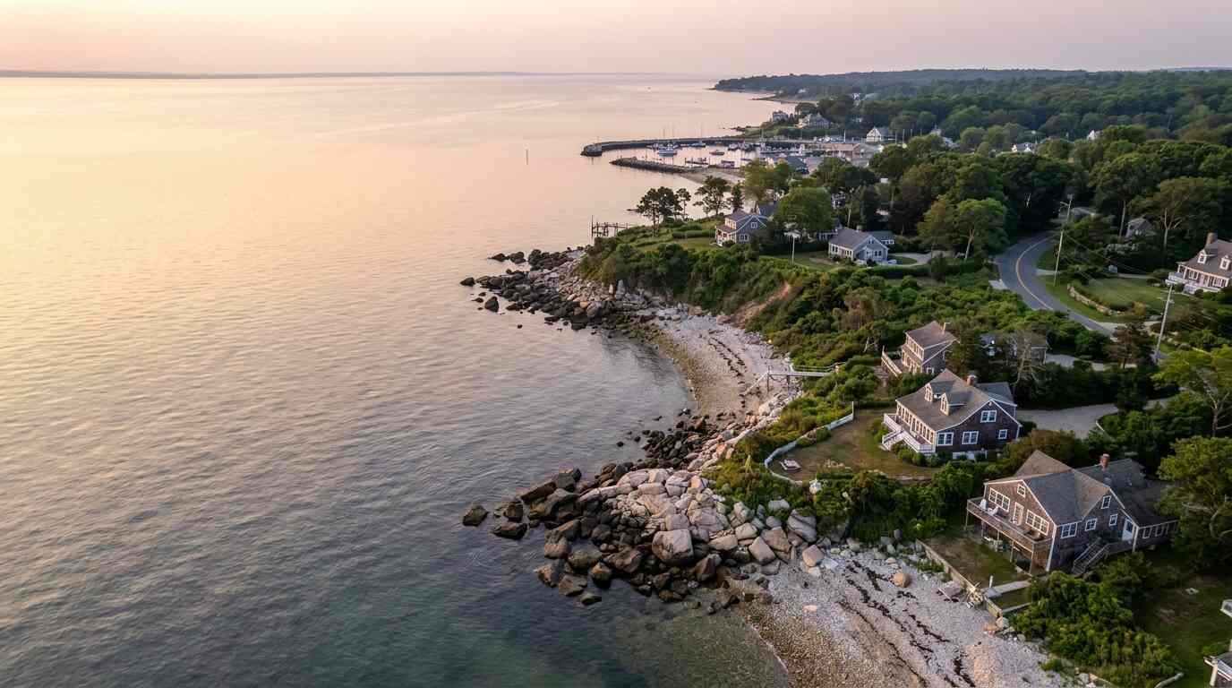
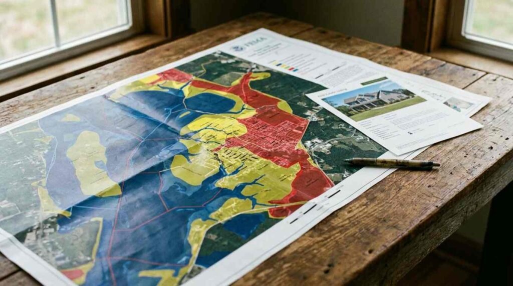
FEMA maps are updated on a rolling basis, but slowly. Climate change is moving faster than the mapping cycle. There are coastal properties on Long Island’s North Shore — including Sound-facing properties in the towns I know best — where the actual flood risk has materially changed since the last FEMA map was drawn, but the designation hasn’t caught up. That gap is real money. It becomes visible at renewal when your insurance carrier runs their own models and sends you a letter that reads nothing like your current policy.
I’ve watched that happen to people. The letter arrives. The number is different. The conversation with the mortgage servicer is not pleasant.
Flood Insurance, FEMA Maps, and the Science They Haven’t Caught Up To
Risk Rating 2.0, which NFIP rolled out beginning in 2021, is the first complete overhaul of how federal flood insurance is priced in fifty years. The old system rated risk by flood zone designation — X, A, AE, VE — and charged premiums by zone. The new system uses property-specific factors: distance to water, elevation, flood frequency, cost to rebuild.
For some properties, rates went down. For others — particularly older structures with low first-floor elevations on coastal or near-coastal lots — rates increased substantially. Some increases are phased in at 18% per year, the statutory cap under federal law. That 18% compounding is not trivial over a five-year horizon.
What Risk Rating 2.0 doesn’t fully account for is the forward-looking science. It reprices based on current and historical risk. The Ditlevsen data — and the broader IPCC and NOAA modeling on sea-level rise under various emissions scenarios — suggests that current risk is already lower than projected future risk. The insurance industry knows this. Private insurers exiting coastal markets in Florida, Louisiana, and California are not exiting because they misread last year’s weather. They’re exiting because their actuaries modeled the next twenty years.
Long Island is not Florida. The North Shore is not Miami Beach. But the physical processes affecting coastal property value don’t stop at the county line.

What a Buyer or Seller Near the Coast Needs to Know Right Now
None of this is a reason to stop buying coastal property. It’s a reason to buy it with clear eyes.
The view doesn’t go away. The location doesn’t go away. What changes is the cost structure beneath it — insurance, maintenance, potential future remediation — and the pricing transparency that buyers increasingly have access to because of tools like First Street Foundation that didn’t exist a decade ago.
Sellers of coastal property need to understand that sophisticated buyers in 2026 are running flood risk assessments before they make offers. The era of “the map says X zone, we’re fine” is over. Buyers’ attorneys are scrutinizing disclosure forms. Buyers’ agents are asking about historical flood events. The due diligence has sharpened because the science has become legible and the insurance repricing has made it financially consequential.
A few things worth knowing before you list or before you bid:
For sellers: Gather your flood insurance history. Know your elevation certificate if you have one. If you don’t have one, get one — it’s a few hundred dollars and it may help your buyer’s insurance quote substantially. Know whether your property has flooded, and know that you’re legally required to disclose it in New York.
For buyers: Ask for the flood insurance quote before you fall in love with the property. Not after. Before. Ask what zone the property is in, when the map was last updated, and whether there is an elevation certificate. Run the First Street Foundation risk score. Look at the DEC tidal wetlands map — the DEC permit requirements for waterfront renovation on Long Island can affect what you’re allowed to do with a property even if you’re not building on wetlands directly.
The ocean has been having this conversation with the coast for a long time. The science just gave it a deadline. Whether the AMOC stabilizes, slows, or tips — and there is genuine scientific disagreement on the timeline — the trajectory of coastal risk pricing is already established. The insurance companies have decided. The actuarial tables have been set.
The question now is whether the buyer in a competitive North Shore waterfront market is making an informed decision or an emotional one. That answer depends entirely on what they knew before they made the offer.
This post is for informational purposes only and does not constitute financial or insurance advice. Real estate markets and flood risk designations change. Consult a licensed insurance professional and your real estate attorney for guidance specific to your property and situation.
Real estate markets change. For current listings and market data, contact Pawli at Maison Pawli.
Sources
- Ditlevsen, P. & Ditlevsen, S. (2023). “Warning of a forthcoming collapse of the Atlantic meridional overturning circulation.” Nature Communications. https://www.nature.com/articles/s41467-023-39810-w
- Alessi, M. (2024). “Why climate scientists are sounding the alarm on the ocean circulation system AMOC.” The Invading Sea. https://www.theinvadingsea.com/2024/11/14/atlantic-meridional-overturning-circulation-amoc-climate-change-sea-level-rise-flooding/
- NOAA Technical Report NOS CO-OPS 083: “Global and Regional Sea Level Rise Scenarios for the United States.” https://oceanservice.noaa.gov/hazards/sealevelrise/sealevelrise-tech-report.html
- First Street Foundation. “The First National Flood Risk Assessment: Defining America’s Growing Risk.” https://firststreet.org/research-library/
- FEMA Risk Rating 2.0: Equity in Action. https://www.fema.gov/flood-insurance/risk-rating
- Sea Level Rise and Home Prices: Evidence from Long Island. The Journal of Real Estate Finance and Economics. https://link.springer.com/article/10.1007/s11146-021-09868-8
- Maison Pawli: Flood Insurance on Long Island’s North Shore: What FEMA Maps Don’t Tell You About Sound-Facing Properties
- Maison Pawli: The DEC Permit Nobody Mentions at the Showing
- Maison Pawli: North Shore Bluff Homes and the Erosion Question