Flood Insurance on Long Island’s North Shore: What FEMA Maps Don’t Tell You About Sound-Facing Properties

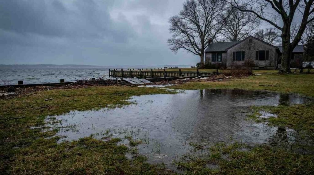
The couple fell in love with a Sound-facing ranch in Centerport — bluff views, mature trees, a staircase down to a private beach. Their lender didn’t require flood insurance. The FEMA map classified the lot as Zone X, which is the designation for minimal risk. They closed, moved in, and eighteen months later, a nor’easter pushed enough storm surge up the bluff face to flood their finished basement and destroy a mechanical system that had just been replaced. The damage came to more than forty thousand dollars. Their homeowners policy covered none of it.
I see versions of this story more often than I’d like. The North Shore’s relationship with flood risk is fundamentally different from the South Shore’s, and the tools most buyers rely on — FEMA maps, lender requirements, even agent assurances — often fail to capture it. If you’re buying waterfront on the North Shore, understanding what those maps actually tell you, and what they leave out, is one of the most consequential pieces of homework you can do before closing.
The Map Is Not the Territory
FEMA’s Flood Insurance Rate Maps classify every parcel in the country into flood zones. The high-risk designations — Zone A, AE, VE — mean your lender will require flood insurance if you have a federally backed mortgage. Zone X means no such requirement exists. For most of the North Shore’s bluff-top properties, the designation is Zone X.
That classification reflects a statistical model: a property’s chance of flooding in any given year is calculated at less than one percent. But “less than one percent” is not the same as zero, and on a thirty-year mortgage, that compounds to a meaningful probability. FEMA itself acknowledges that roughly forty percent of all flood insurance claims nationally come from properties outside designated high-risk zones. The North Shore’s irregular topography — steep bluffs, tidal harbors, low-lying creek inlets — means that localized flooding can occur in places the broad-stroke FEMA maps never flag.

Risk Rating 2.0 Changed the Math
The pricing system most buyers still think of when they hear “flood insurance” no longer exists. In 2021, FEMA began rolling out Risk Rating 2.0, a complete overhaul of how the National Flood Insurance Program calculates premiums. The old method grouped properties by flood zone and elevation relative to a base flood level. The new method prices each property individually, factoring in distance from the nearest water source, types of flooding the property faces (coastal surge, riverine, pluvial), the structure’s replacement cost, its foundation type, and its claims history going back twenty years.
For Long Island, this shift has been significant. Properties in lower-risk zones that were previously eligible for preferred rates under the old system may now see premium increases as Risk Rating 2.0 aligns their cost with actual risk. The increases are capped at eighteen percent per year by federal law, but they compound — and for some North Shore waterfront properties, the eventual full-risk premium is substantially higher than what the previous owners were paying. The national average NFIP premium is roughly $900 per year, but individual properties with higher risk profiles can see premiums well above that figure.
The critical detail for buyers: when a property changes hands, the new owner doesn’t automatically inherit the seller’s rate. If the existing flood insurance policy isn’t formally assigned to the buyer at closing, any grandfathered discount the seller carried may be lost. The new policy will be priced at Risk Rating 2.0’s full actuarial assessment of that specific property. I always tell buyers to ask their closing attorney about policy assignment well before the closing date — not the day before.
What the Map Misses on the North Shore
The North Shore’s flood risk profile differs from the South Shore in ways that FEMA maps handle unevenly. The South Shore faces broad-area coastal flooding from Atlantic storms, which FEMA maps capture relatively well. The North Shore faces a more complex combination of threats: storm surge from Long Island Sound, which behaves differently than open-ocean surge; harbor flooding in enclosed embayments like Port Jefferson, Northport, and Cold Spring Harbor; bluff-face erosion that can redirect water flow patterns over time; and freshwater flooding from creek systems that discharge into the Sound.
Several North Shore communities sit in that uncomfortable middle ground where the official map says “low risk” but the local history says otherwise. Properties in Bayville, parts of Asharoken, and sections of the Sands Point peninsula have experienced repeated flooding events despite Zone X or moderate-risk designations on the official maps. The issue isn’t that FEMA is wrong — it’s that the maps were designed for broad floodplain management, not for individual property-level decision-making, and they’re updated irregularly. Some of the maps still in effect for parts of Suffolk County reflect data that predates Superstorm Sandy.
The Private Market Alternative
The NFIP isn’t the only option. Private flood insurers now compete in the market, and for some North Shore properties, a private policy may offer better coverage, higher limits, or more competitive pricing. The NFIP caps structural coverage at $250,000 and contents at $100,000 — numbers that leave significant gaps for many North Shore homes. A private policy can exceed those limits, though at a higher premium.
The tradeoff is continuity: NFIP policies can be transferred to new owners and carry regulatory protections. Private policies are subject to the insurer’s underwriting decisions and may not be renewed. For a property you plan to hold long-term, weigh both options with an insurance broker who specializes in flood coverage — not your general homeowners agent.
What Buyers Should Do Before Closing
Start with FEMA’s Flood Map Service Center — enter the property address and review the current FIRM panel. But don’t stop there. Look at the property’s elevation certificate, if one exists; your surveyor or the municipal building department may have one on file. Ask the seller or their insurance agent for a copy of any existing flood insurance policy, including the claims history. Under Risk Rating 2.0, a property’s past claims are a pricing input, and properties with multiple claims may carry a surcharge that the buyer inherits.
If the property sits within three hundred feet of a tidal wetland boundary — which many North Shore waterfront properties do — there are additional regulatory layers that may affect renovation plans and, indirectly, insureability. I’ve written about DEC wetlands permits separately, but the insurance question and the regulatory question are more connected than most buyers realize.
Finally, talk to the neighbors. In my experience, flooding history is oral history. The FEMA map may say Zone X, but the woman three doors down remembers the water in her garage in 2012, and the couple across the street replaced their furnace after a nor’easter in 2018. That kind of local knowledge doesn’t appear on any map, but it should inform your insurance decision.
This is for informational purposes only — consult a licensed insurance professional for coverage advice specific to your situation, and a licensed attorney for any legal questions related to your purchase.
Real estate markets change. This post reflects conditions as of April 2026. For current listings and market data, contact Pawli at Maison Pawli.
This post is part of my comprehensive guide to Buying Waterfront Property on Long Island’s North Shore: What Every Buyer Needs to Know — covering everything from flood insurance and DEC permits to bulkheads, riparian rights, and the waterfront buyer’s checklist.
You Might Also Like- North Shore Bluff Homes and the Erosion Question: What Buyers Need to Know
- Holding Back the Sound: The Brutal Economics of North Shore Bulkheads
- Where Does Your Property Actually End? The Legal Swamp of East End Dock Rights
Sources
- FEMA Flood Map Service Center — https://msc.fema.gov/portal/search
- FEMA Risk Rating 2.0 Overview — https://www.fema.gov/flood-insurance/risk-rating
- Congressional Research Service, Risk Rating 2.0 FAQ — https://www.congress.gov/crs-product/IN11777
- U.S. GAO, Flood Insurance: FEMA’s New Rate-Setting Methodology (July 2023) — https://www.gao.gov/products/gao-23-105977
- National Association of Realtors, Risk Rating 2.0 Myth Buster — https://www.nar.realtor/flood-insurance/nar-myth-buster-fema-risk-rating-2-0
- Suffolk County Emergency Management — https://www.suffolkcountyny.gov/mend/risk.html
- American Flood Coalition, Risk Rating 2.0 Explainer — https://floodcoalition.org/flood-insurance-and-risk-rating-2-0-everything-you-need-to-know-in-five-minutes/