Piping Plovers and Permit Systems: How Suffolk County’s Beach Access Policies Are Functioning as De Facto Habitat Management — Whether They Mean To or Not
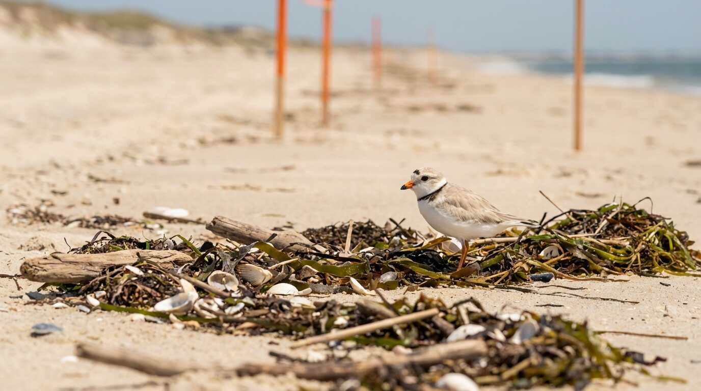
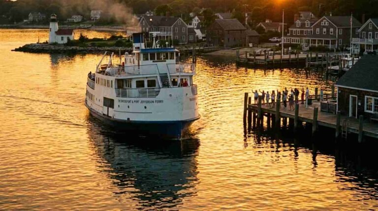
Every spring I notice something about the South Shore that the people driving past Smith Point on the Sunrise Highway don’t. The fences go up. The orange corridor markers appear. The ORV permit windows open at the county parks offices. And somewhere in the wrack line east of the parking lot, a pair of piping plovers — state-endangered, federally threatened, barely four inches of bird — begins scraping a shallow nest into the open sand.
The permit system wasn’t designed for the plovers. It was designed for the truck owners. But the two systems have arrived at an uneasy ecological coexistence, and the result is something that conservation biologists have begun studying seriously: Suffolk County’s patchwork of municipal beach access rules is functioning, unintentionally, as one of the more effective shorebird protection regimes on the northeastern Atlantic flyway.
The Bureaucratic Accident That Became a Refuge
To understand how this happened, you need to understand what a piping plover actually requires. Charadrius melodus is a bird of the disturbance economy — it evolved to nest on the dynamic, storm-raked barrier beaches where vegetation is minimal, predator cover is low, and the sand is open enough to render a four-egg clutch nearly invisible. What it cannot tolerate is pressure. A dog off-leash. An ATV running the wrack line at dawn. A beachgoer who doesn’t see the nest until the boot is already falling.
Historically, Long Island’s barrier beaches provided all of this in abundance. The Atlantic Coast population of the piping plover had an estimated 500 breeding pairs on Long Island in 1939, according to early surveys cited in the New York State Department of Environmental Conservation’s species profile. By the late 1980s, after decades of unmanaged coastal recreation and postwar development, that number had collapsed to roughly 190 pairs annually — a reduction of more than 60 percent. The federal threatened listing came in 1986. The New York state endangered listing followed.
What reversed the collapse, slowly and incompletely, was management. Exclosures around individual nests. Symbolic fencing at colony edges. Annual monitoring by DEC, Audubon New York, the U.S. Fish and Wildlife Service’s Long Island Field Office, and networks of trained volunteers. But woven through all of it — less deliberately, more consequentially — was the ORV permit structure that Suffolk County had built for entirely different reasons.
What the ORV Corridors Actually Do
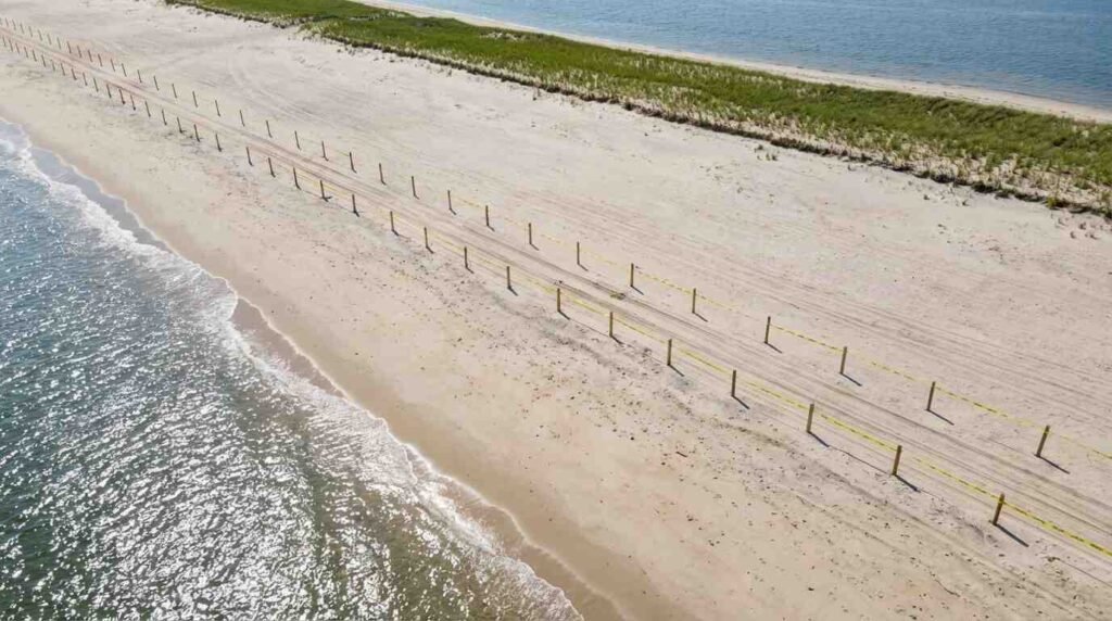
At Smith Point County Park, at Cupsogue Beach, at the western reach of Shinnecock County Park, the Department of Parks administers off-road vehicle access through a seasonal permit system. The permits are priced. The corridors are mapped. The hours are restricted. And during nesting season — roughly April through August, depending on fledging success — sections of beach are closed outright, with the closure boundaries tied not to bureaucratic preference but to where the birds actually are.
The closures are implemented because federal and state law require it: the Migratory Bird Treaty Act of 1918 protects piping plovers and their nests, and any take — disturbance that causes nest abandonment, egg breakage, or chick death — carries legal jeopardy. Suffolk County’s parks administrators are not ornithologists. They are managing liability. But the ecological outcome is a defended zone.
Shorebird biologists who have compared nesting success across permit-restricted beaches and formally designated critical habitat have found something instructive: the functional protection is often similar. What matters to a piping plover is not the legal designation of the ground beneath the nest. It’s the absence of the thing that kills the chick. Permit corridors that redirect ORV traffic away from the high-tide wrack line — where chicks forage for polychaete worms and amphipods in the days after hatching — reduce mortality in ways that parallel formal refuge management, even when the mechanism is a parking fee and a paper permit rather than a federal register designation.
The NYSDEC monitors breeding pairs along Long Island’s Sound-facing and Atlantic-facing beaches annually, alongside the Long Island Sound Partnership’s shorebird indicator dataset, which has tracked piping plover productivity at North Shore sites including Peconic Bay and Shelter Island since the early 1990s. The data show nesting success improving on managed beaches since formal monitoring began in 1984, with the steepest gains at sites where access restriction is most consistent.

Three Species, One Corridor
The piping plover is the species that generates the policy conversation, because it carries the federal threatened listing and the legal weight that comes with it. But it shares the corridor with two other species whose nesting requirements are broadly similar and whose numbers tell the same story.
American oystercatchers (Haematopus palliatus) nest on barrier beach overwashes and vegetated dune edges. They lay two to four eggs in an open scrape, incubate for 24 to 28 days, and tend precocial chicks who cannot fly for another five weeks. During that window — six to seven weeks of ground-level exposure — an unmanaged beach is a gauntlet. A permit corridor that eliminates ORV traffic from the overwash removes most of the mortality pressure. Audubon New York monitors oystercatcher nesting at Long Island sites alongside plover colonies, and the overlapping habitat requirements mean that a beach managed for one species tends to support both.
Least terns (Sternula antillarum) nest in colonies, often on the same barrier spits that piping plovers favor, and rely on the open sand that the permit corridors protect from trampling and vehicular compaction. They are more tolerant of human activity at the colony edge — they mob intruders aggressively — but colony abandonment in the face of sustained pressure is well documented. On beaches where ORV access is permit-controlled and timed to avoid the colonial nesting peak, least tern productivity improves by a margin that parallels outcomes at formally protected sites.
This is the ecological reality that no beach permit application mentions: when a Suffolk County resident pays $185 for an ORV permit and accepts the seasonal corridor restrictions as a condition of access, they are entering into a contract that has shorebird conservation as one of its functional terms. Neither party knows this, which may be why it works.
The Tension That Hasn’t Been Resolved
None of this should obscure the conflict. The barrier beaches of Suffolk County are under enormous recreational pressure, and the people who use them — legitimately, joyfully, with deep attachment to a way of life that is itself native to this place — experience the nesting closures as restrictions that appear and disappear on schedules they don’t control. The ORV community on Long Island is organized, vocal, and not wrong that the fences sometimes go up over areas that seem, to the eye, like ordinary beach.
The ecology of nesting shorebirds is counterintuitive. The scrape is invisible. The chick is invisible. The corridor that looks empty from behind a windshield is doing work that won’t show up in any of the places beach users look. This is not a failure of the permit system — it is a failure of the public explanation surrounding it.
What Long Island’s beaches have accidentally produced is a distributed conservation infrastructure: a set of temporarily defended zones, tied to the actual location of breeding activity rather than to fixed boundaries, administered by people whose primary concern is park operations rather than wildlife biology, and nonetheless producing habitat refugia that rival formally designated critical habitat in their functional effect. Peer-reviewed research on beach-nesting shorebird response to recreational disturbance — including Joanna Burger’s foundational work on the subject — has consistently shown that the variable driving nesting success is not the legal status of the beach but the effective distance between human activity and the nest. Suffolk County’s permit corridors, whatever their original rationale, create that distance.
What a Broker Sees
I spend a lot of time near these beaches. I’ve shown waterfront listings at Cupsogue, walked the bluff-edge properties at Smith Point, driven the causeway to Fire Island more times than I can count. And every spring I notice what happens when the orange markers go up: the beach quiets in a specific way. The terns arrive. The oystercatchers start patrolling the overwash. The plovers, if you know where to look, are already there.
There is something worth thinking about in the fact that the same permit system that makes barrier beach access manageable for the people who live and play here is also, inadvertently, keeping a threatened species from disappearing from this coast. The bureaucracy and the ecosystem arrived at an accommodation that neither designed and neither fully understands. That is, actually, the way a lot of important things survive.
Sources
- U.S. Fish and Wildlife Service — Long Island Ecological Services Field Office
- NYSDEC — Piping Plover Species Profile
- New York Natural Heritage Program — Piping Plover Guide
- Long Island Sound Partnership — Piping Plovers Indicator
- Audubon New York — Threatened and Endangered Birds Begin Nesting Season on Long Island
- Fire Island National Seashore — Piping Plover Monitoring and Management
- NYSDEC Species Assessment for Piping Plover: extapps.dec.ny.gov
- Burger, J. (1987). Physical and social determinants of nest site selection in piping plover in New Jersey. Condor, 89:881–918.
You Might Also Like
- The Dune Road That Drowned: How Fire Island’s Original Shore Road Disappeared Beneath the Atlantic
- The Sunken Meadow Sanatorium and the Beach Nobody Remembers Was a Tuberculosis Cure
- The Eelgrass Crisis in Peconic Bay — and Why Every Bayfront Buyer in Southold and Shelter Island Should Read the Water Quality Data Before Closing