The Other Patagonia: What Happens When You Cross into Chile Instead of Turning Back
Most people who come to the end of the world stop at Torres del Paine. A few keep going — into the channels, into the rain, into a landscape so extreme that the Chilean Navy still considers parts of it uncharted.
The Patagonian steppe ends where the fjords begin, and the fjords begin abruptly. You are on open grassland, the wind moving the brown grass in long waves, the sky enormous and the mountains visible at the far end of it — and then the land dissolves into channels, the channels multiply, the rain that has been threatening since breakfast becomes the condition of everything, and the concept of a road becomes increasingly theoretical. This is where Chilean Patagonia proper starts, south of Puerto Natales, and where the majority of visitors to the region stop going.
Última Esperanza
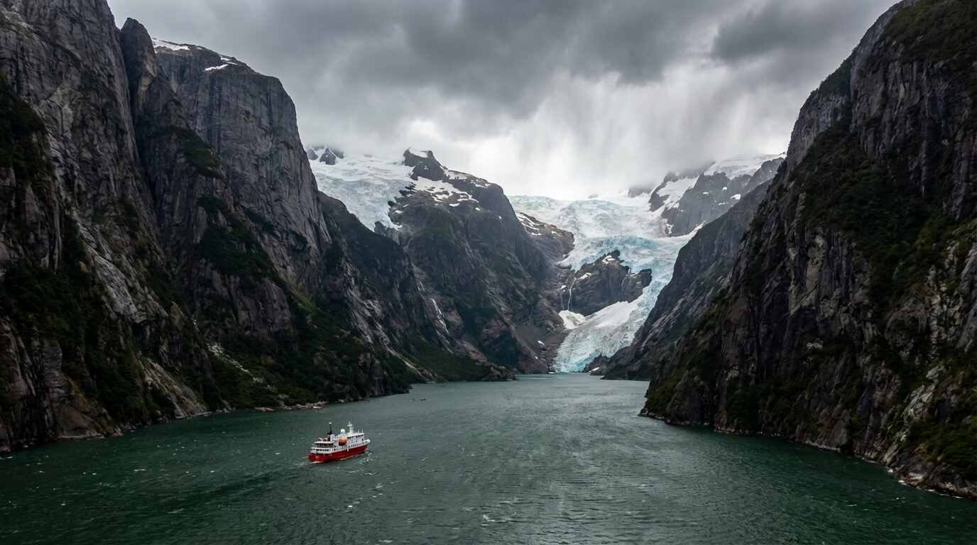
The name means Last Hope, and it was assigned to the sound — Seno Última Esperanza — by the Spanish explorer Juan Ladrillero in 1557, who was searching for a western passage to the Strait of Magellan and found instead a fjord that ended. The name has the quality of the place: not dramatic, exactly, but precise about its own extreme character. The fjord runs north from Puerto Natales into the mountains of the Torres del Paine massif, the glacier fronts of the Southern Patagonian Ice Field visible at its head. It is the gateway to the national park and the most visited water in the region by a significant margin.
South of Puerto Natales, the visitor numbers drop. The Última Esperanza region transitions into Magallanes, and Magallanes transitions into the fjords and channels of the Tierra del Fuego archipelago, and at each transition the infrastructure thins and the landscape intensifies. The Chilean National Forestry Corporation (CONAF) visitor records for Cabo de Hornos National Park — which encompasses the archipelago south of Tierra del Fuego including Cape Horn itself — document visitor numbers that reflect the practical difficulty of reaching it: not many, by any measure applied to major national parks elsewhere.
The Ventus Australis and What Expedition Vessels Offer
The most documented access to the Cape Horn archipelago and the Beagle Channel fjords is by small expedition vessel, specifically the Australis operation running the Ventus Australis between Punta Arenas and Ushuaia, Argentina, in both directions. The itinerary covers the channels that Darwin described in the 1830s with a combination of astonishment and discomfort, the same weather that made the Beagle‘s progress through these waters so slow and technically demanding still operating on the same schedule. The fjords narrow and the mountains rise directly from the water and the glaciers appear around corners and calve into the channels at intervals that are impossible to schedule. You watch from the deck or from the inflatable zodiac shore excursions that land at the few places landing is possible.
The scale problem of the southern Chilean fjords is the central experience: you lose human reference points. The mountains are too tall for the vertical angle to be comfortable, the distances across the channels too wide for the opposite shore to provide scale, the sky too overcast and moving too fast to provide orientation. What remains when all the reference points dissolve is the landscape itself, operating entirely without interest in your interpretation of it.
The Estancias
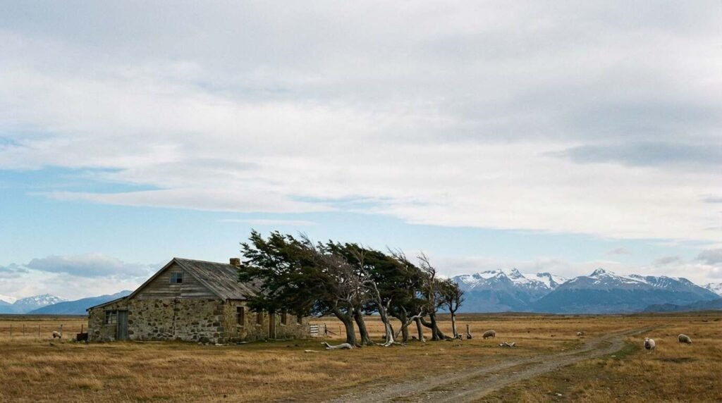
Inland from the channels, accessible by charter flight on gravel airstrips or by four-wheel-drive on roads that the word optimistically describes, the Patagonian estancias represent a different order of remoteness. These sheep-farming estates — some of them established in the late nineteenth century by British, Croatian, and Spanish settlers who came south during the wool boom — operate in a landscape that the twentieth century largely bypassed. The infrastructure is functional and spare: the main house, the worker housing, the shearing shed, the corrals, the windmill. Some have opened to guests, offering accommodation in the spare rooms of working farm buildings, meals from the kitchen that feeds the farm workers, horseback access to territory that no road reaches.
The estancias that see fewer than a few hundred visitors annually are the ones worth the logistical effort. The experience of being on a working farm at the end of the hemisphere, where the weather is the primary fact of every day and the landscape extends without interruption to the horizon in every direction, produces a quality of attention that compressed itineraries do not allow. You stay long enough to watch the light change over two or three days, and the light changes dramatically — the cloud systems moving fast across the open steppe, the late Patagonian afternoon stretching toward ten at night in summer, the colors at the end of the day something that painters have been trying and largely failing to get right since the nineteenth century.
The Weather as Content
Patagonian weather is not background. It is the subject. The wind that crosses the southern cone from the Pacific, having gathered speed across the Drake Passage and the open South Atlantic with nothing to interrupt it, arrives in the channels and the steppe with a consistent authority that the region’s entire built environment has been designed around. The estancia houses face away from the prevailing wind. The trees, where trees can grow, have been bent permanently in the direction of the prevailing wind, their branches stripped and their trunks inclined. The sheep move away from it instinctively.
In the channels, the williwaw — a sudden violent downrush of cold air from the mountains — can arrive in seconds and change a navigable sea condition to something else entirely. Darwin described williwaws in his Patagonian journals. The Ventus Australis crew describe them in the same terms two centuries later. The wind has not changed.
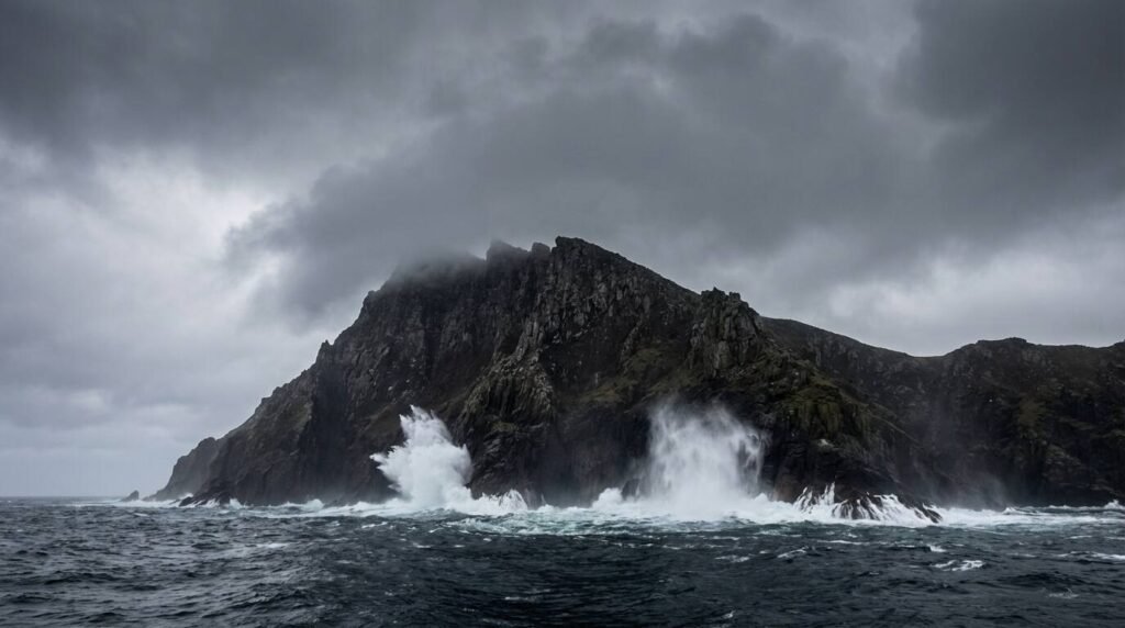
Cape Horn
Cape Horn is a rock — a 425-meter cliff face at the southern tip of Hornos Island, the southernmost point of the Americas. CONAF administers it as part of the Cabo de Hornos National Park, and the park infrastructure at Cape Horn itself consists of a lighthouse, a Chilean Navy station manned by a single family who rotate annually, a small chapel, and a sculpture of an albatross dedicated to the sailors who died rounding the Horn under sail. The albatross figure has its wings spread into the prevailing wind.
Landing at Cape Horn requires conditions that do not often obtain — calm enough for zodiac operations, which means not the conditions most associated with the place. When it is possible to land, the walk to the cliff edge takes twenty minutes through tussock grass and wind that requires leaning into. The ocean below is the Drake Passage. The next land south is Antarctica. The lighthouse keeper’s family, if you meet them, has the quality of people who have thought carefully about what is important and made specific decisions accordingly.
I think about extreme places the way I think about properties that require real commitment: the ones that don’t apologize for what they ask of you. Chilean Patagonia south of Torres del Paine doesn’t apologize. It presents the weather and the distance and the logistical difficulty without softening them, and what you get in return is a landscape that is entirely itself — not organized for your arrival, not managed for your comfort, not performing. That’s increasingly rare, in destinations as in houses. When you find it, you understand what you’ve been settling for everywhere else.
Sources
– Australis Expeditions, Ventus Australis: australis.com – Chilean National Forestry Corporation (CONAF), Cabo de Hornos National Park: conaf.cl – National Geographic, Patagonia coverage: nationalgeographic.com – Condé Nast Traveler, Patagonia reporting: cntraveler.com