Cedar Beach’s Eroding Bluffs as Open Archive: The Mount Sinai Harbor Shoreline’s Exposed Stratigraphy as an Accidental Archaeological Site
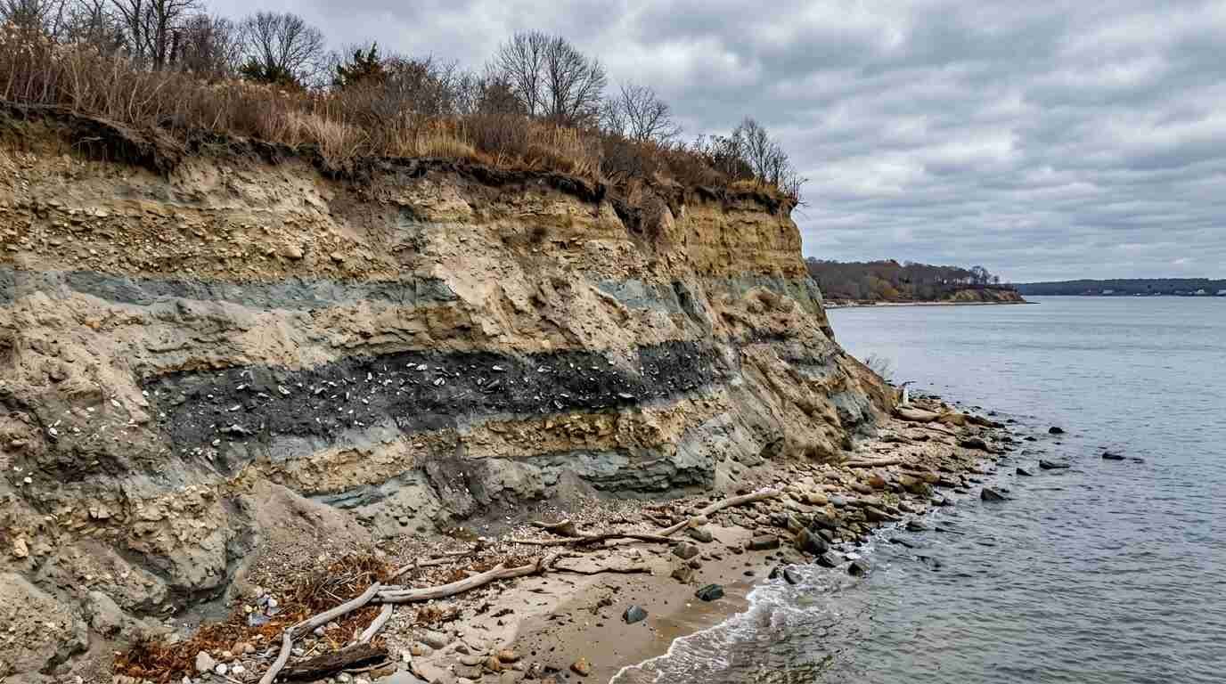
There is a morning in late October when Cedar Beach reads like a different place. The summer people are gone. The parking lot is empty. The bluff face above the harbor — the one that runs south of the beach access, where the clay and gravel mix is visible in horizontal bands along the cutbank — is catching the flat autumn light at an angle that makes every irregularity in its surface legible. The exposed layers. The dark organic zones. The glint, if you are looking closely enough, of something that does not belong in the matrix.
I grew up coming to this harbor. I know where the good anchorage is, and I know the north shore bluff erosion problem in the way that anyone who has been watching these properties for a decade knows it — personally, with some concern, because the erosion does not stop when it becomes inconvenient for property values. But I have also learned, more slowly, to look at that erosion as something other than damage. The bluff face that is retreating is also, in the precise sense, being excavated. Every storm season strips another layer. Every spring thaw loosens another section. And what keeps falling out of those cliff faces — documented in SHPO site inventory records and in New York Sea Grant coastal erosion monitoring data — is rewriting the quiet coastal history of one of Long Island’s most overlooked harbors.
The Erosion Record and What It Contains
Cedar Beach and the Mount Sinai Harbor shoreline sit within what the NYSDEC designates as a coastal erosion hazard area under Brookhaven Town jurisdiction. The erosion monitoring data collected by New York Sea Grant and the NYSDEC tracks rates of bluff retreat along this section of the north shore, and those rates have accelerated over the past several decades as storm frequency and intensity have increased.
What the erosion is exposing is a stratigraphic sequence that was laid down over a much longer period than the management horizon of any NYSDEC program. The bluff faces along Mount Sinai Harbor cut through sediment layers that record the full post-glacial history of this coastal zone: the glacially deposited till and outwash at the base; the post-glacial shoreline sediments above it; the layers of soil and organic material that accumulated during the period of Algonquian occupation; and, at or near the surface, the deposits associated with colonial and post-colonial land use.
Published reports by the Public Archaeology Laboratory on Long Island north shore pre-contact sites provide the interpretive framework for what this stratigraphic sequence contains archaeologically. The Mount Sinai Harbor area sits within documented Setalcott territory. The SHPO site inventory for northern Brookhaven records multiple pre-contact site locations in the vicinity — shell middens, fire-cracked rock concentrations, isolated artifact finds — that establish sustained Setalcott use of this coastal zone over an extended period.
What the Bluff Face Yields
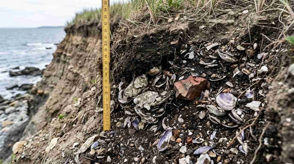
Shell middens are the most immediately recognizable archaeological deposit eroding from these bluff faces. A midden — the technical term for an accumulated refuse deposit, used by archaeologists with the specific meaning of a shell heap produced by sustained shellfishing activity — appears in the bluff cross-section as a dense concentration of oyster, quahog, and soft-shell clam shell, often intermixed with fire-cracked rock, charcoal, and the occasional ceramic fragment or worked bone.
The shell middens documented along the Mount Sinai Harbor shoreline in the SHPO inventory represent Setalcott use of this specific coastal environment for shellfishing over an extended period — centuries, in some cases, based on radiocarbon dating of comparable deposits along the north shore. They are not random accumulations. They are the physical record of a food economy, a technology (the boiling pits and roasting features that fire-cracked rock indicates), and a pattern of seasonal land use that left this particular stretch of coastline as a preferred working shore.
Fire-cracked rock and ceramic fragments eroding from the bluff face alongside the shell material complete the picture. Ceramic sherds allow archaeologists to assign a rough temporal position to a deposit based on the ceramic tradition they represent — pre-contact Algonquian wares, early contact-period wares with European influence, colonial-era English wares that indicate post-contact use of the same location. A bluff section that contains all three in vertical sequence is an extraordinarily compact record of cultural continuity and change across the contact period.
The Erosion Rate Is Also the Discovery Rate
Here is the uncomfortable arithmetic of coastal archaeology on eroding bluffs: the faster the erosion, the faster the discovery. Deposits that might have remained sealed in the bluff for another century are being exposed in a decade. That exposure is simultaneously an opportunity and a crisis — an opportunity because previously unknown sites are becoming visible; a crisis because what erosion exposes, it also destroys. A sherd that falls from the bluff face to the beach below is no longer in context. Its position relative to the other materials in the deposit — the spatial information that makes interpretation possible — is gone.
The standard archaeological response to this problem is monitoring and rapid documentation. The SHPO site inventory process attempts to identify and record sites as they appear, but the monitoring resources applied to actively eroding north shore bluffs are not proportional to the rate at which those bluffs are yielding new material. Most of what Cedar Beach’s bluff face is producing falls to the beach below and is lost before anyone with the relevant training sees it.
This is not a reason for despair. It is a reason to pay attention — and to understand what is happening at this shoreline as something more than a property damage problem. The bluff erosion that threatens waterfront property values along Mount Sinai Harbor is simultaneously conducting an inadvertent excavation of the human history encoded in those bluffs. The two facts coexist, and they complicate each other.
What Buyers Here Need to Know
North shore bluff properties and the erosion question is a subject I’ve covered in depth, and I want to be precise here about the intersection of the archaeological and the practical.
Properties adjacent to the Cedar Beach shoreline fall within the NYSDEC Coastal Erosion Hazard Area. Shoreline stabilization work — bulkhead installation, revetment, bluff face stabilization — requires NYSDEC permits and may require consultation with SHPO if the work area intersects with an identified or suspected archaeological site. That consultation process is not a barrier; it is a step in the permitting sequence, and it is navigable with competent environmental and legal counsel.
What it adds to the cost and timeline of waterfront work in this area is predictable if you know about it in advance and unpredictable if you don’t. That is precisely the kind of information I try to surface early in a buyer conversation about bluff properties on this harbor.
The archaeology is not a problem. It is part of what this place is — the material record of an occupation that predates the current ownership of these properties by a very large margin. The bluff face eroding into the harbor is doing something that no deed search can do: it is producing evidence of who used this water before the deeds existed. That evidence is fragile, it is partially irretrievable, and it is real.
Sources
- New York Sea Grant coastal erosion monitoring: https://seagrant.sunysb.edu/coastal
- NYSDEC Coastal Erosion Hazard Area maps for Brookhaven Town: https://www.dec.ny.gov/lands/86873.html
- SHPO site inventory for northern Brookhaven: https://www.nysparks.com/shpo/
- Public Archaeology Laboratory — Long Island north shore pre-contact site reports: https://www.palinc.com
Mount Sinai is one of the communities profiled in my North Shore Long Island Neighborhoods: The Insider’s Guide to Where to Live — I live here, I work here, and the guide covers what makes this hamlet distinct on the North Shore, from lot sizes to school districts to the harbor that defines it.