Hidden Beach, Hidden Function: The Ecological Services Performed by Long Island’s Least-Visited Pocket Beaches That No One Is Accounting For
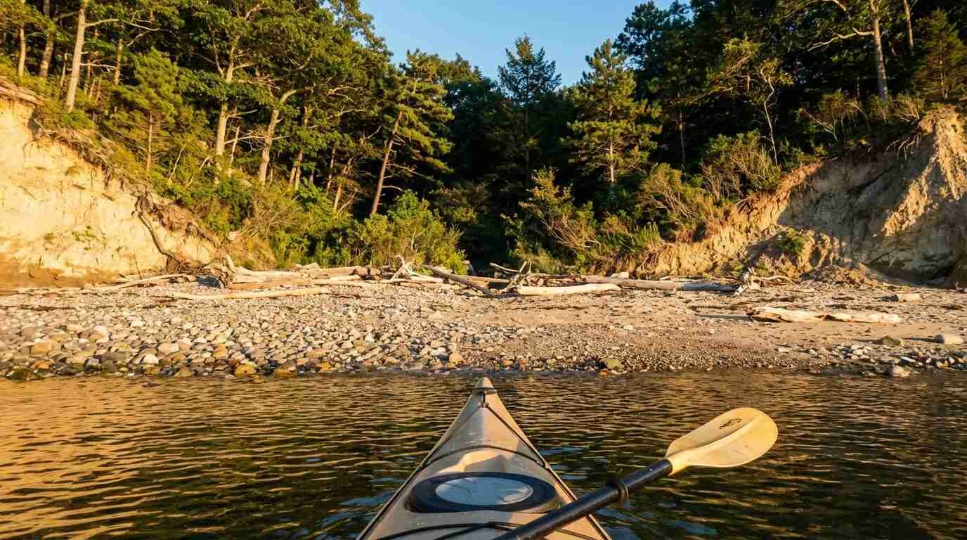
Getting to the pocket beach at the western edge of Caumsett State Historic Park Preserve requires either a two-mile walk from the parking area or a kayak launched from Lloyd Harbor. There is no signage at the beach itself. There is no lifeguard, no trash can, no parking, no concession stand. What there is, in late spring and early summer, is a shoreline doing a level of ecological work that the managed beaches five miles away — with their daily grooming, their ORV corridors, their thousands of summer visitors — simply cannot perform.
The beach doesn’t know this. It just does it.
What Makes a Pocket Beach Different
Long Island’s North Shore is not a barrier island coast. It is a glacially sculpted margin of headlands, bluffs, coves, and protected embayments — the product of terminal moraine deposition that created a highly irregular shoreline where a ten-minute walk around a headland can move you from a sheltered gravel cove to an exposed rocky point to a sand-bottom inlet. The pocket beaches tucked between those headlands are small, often cobbled or mixed sand-and-gravel in composition, and almost always inaccessible by vehicle. Many are reachable only by water or by unmarked foot trails through the upland.
That inaccessibility is not incidental. It is the ecological condition from which everything else follows.
The NYSDEC designates Caumsett State Historic Park Preserve — which encompasses over 1,500 acres on the Lloyd Neck peninsula, including significant Sound-facing shoreline — as both a Significant Coastal Fish and Wildlife Habitat and a Bird Conservation Area. The park’s shoreline supports nesting piping plovers and least terns, osprey, and wintering waterfowl, and the rocky intertidal zone hosts communities of organisms that depend on substrate stability and low human disturbance. In January 2026, Governor Hochul announced a 180-acre expansion of the preserve, adding 12 acres of estuarine and marine wetlands adjacent to Lloyd Neck Harbor — a direct acknowledgment of the coastal habitat value concentrated on this peninsula.
But the state’s formal designations capture only part of the story.
Wrack as Ecosystem
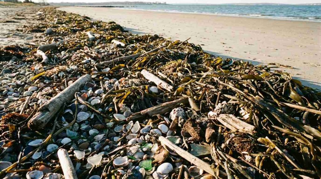
On beaches that are groomed — raked daily, cleared of debris, maintained in the smooth, uniform condition that beach-going humans prefer — wrack decomposition does not occur. The wrack line, that tangled margin of seaweed, shell hash, driftwood, and organic debris that the tide deposits above the high-water mark, is the productive edge of the beach system. It is where amphipods and isopods and talitrid crustaceans — the “beach hoppers” that children turn over wet kelp to find — concentrate in densities that support foraging by shorebirds, songbirds moving through in migration, and small mammals.
On a groomed beach, the rake comes through and removes it. On an ungroomed pocket beach tucked behind a headland, it accumulates, decomposes, and feeds the invertebrate community that makes the beach ecologically productive. This is not a romantic observation about wildness. It is a trophic accounting: a groomed beach is a beach from which a caloric subsidy has been removed.
The supratidal zone above the wrack line performs another function that high-use beaches cannot. Beach-nesting invertebrates — several species of ground-nesting bees and wasps, tiger beetles in their larval burrow phase — require uncompacted sand in the supratidal zone. Repeated foot traffic compacts the substrate to a density that makes burrowing impossible, and on popular beaches the supratidal zone receives enough summer pressure to effectively exclude these communities. On pocket beaches with no regular human access, the supratidal remains loose and permeable — a substrate that supports communities of invertebrates that are themselves important prey for the birds that stop here.
The Nearshore Zone No One Manages
Below the high-tide line, the ecological services of Long Island’s undisturbed pocket beaches extend into the water column in ways that the surface perspective misses entirely.
In the protected, low-turbidity nearshore zones that characterize the coves and embayments of the Lloyd Neck shoreline, the Nissequogue River State Park coastal margin, and the shallows adjacent to the Sound-facing pocket beaches of the North Shore, submerged aquatic vegetation — primarily eelgrass, Zostera marina — can establish and persist in the absence of boat propeller scarring, anchoring disturbance, and the turbidity that heavy recreational use generates in shallow water. Eelgrass meadows are among the most productive marine habitats in the temperate zone: nursery habitat for juvenile finfish and shellfish, nitrogen filtration, carbon sequestration, and stabilization of bottom sediments that would otherwise become turbidity sources.
The eelgrass crisis in Peconic Bay — which I wrote about in an earlier post — is partly a story about what happens when these conditions are lost at scale. The pocket beaches of the North Shore, accessible only to the patient or the well-kayaked, still have the nearshore conditions that eelgrass requires. The inaccessibility that makes them unremarkable to the recreational user is the condition that makes their nearshore zones productive.
Obscurity as Conservation Strategy
There is a question worth sitting with: is the obscurity of these beaches itself a conservation outcome, or merely a precondition of one?
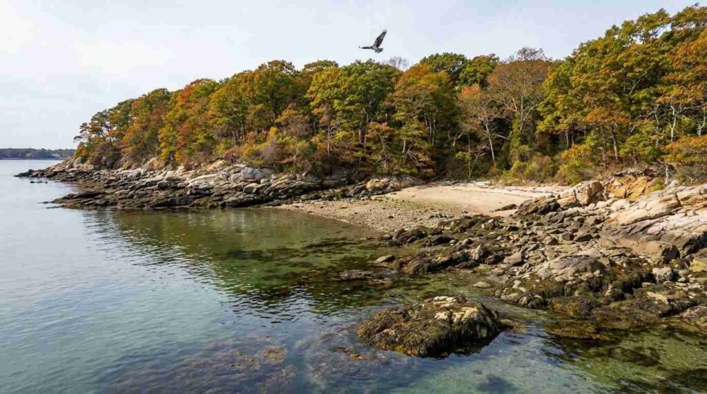
The Caumsett Foundation, the volunteer organization dedicated to the preserve, has documented the presence of the only known Long Island breeding colony of the Baltimore Checkerspot butterfly — a regionally imperiled species — within the preserve’s boundaries. The colony was discovered in 2009. It had presumably been there for some time before anyone noticed. The bird conservation area of the park hosts osprey, common loon, and bald eagle, in addition to the nesting shorebirds. The shoreline has been designated a Significant Coastal Fish and Wildlife Habitat by NYSDEC, a designation that formally recognizes ecological value but does not by itself protect against gradual degradation.
Target Rock National Wildlife Refuge, located approximately two miles east of Caumsett on Lloyd Neck, protects an additional 80 acres of rocky shore and coastal bluff habitat — a formally managed unit whose protection of piping plover and least tern nesting directly benefits from the low-pressure shoreline adjacent to it. The conjunction of formally protected refuge, state historic preserve, and the simple fact that you can’t drive to most of the shoreline creates a corridor of ecological function along the Lloyd Neck peninsula that is probably more intact than any comparable length of North Shore coastline on Long Island.
The Nissequogue River State Park, on the western bank of the Nissequogue River in Smithtown, adds another element: the tidal margin where river and Sound meet creates a gradient of salinity, sediment type, and hydrodynamic energy that supports distinct community assemblages at each point along it. NYSDEC’s Significant Coastal Fish and Wildlife Habitat designations for the Nissequogue River include the coastal bluff and beach habitat that forms the park’s Sound-facing edge. Those bluffs are eroding — glacial till and clay do not hold against the Sound indefinitely — but the coves and rocky points at their base continue to function as low-disturbance nursery habitat.
The Accounting That Isn’t Happening
What no state park management plan, no beach permit program, no county parks operations budget currently accounts for is the aggregate ecological value of these pocket beaches considered as a system. Each one is small. Each one is managed — to the extent it is managed at all — in isolation. The unit management plan for Caumsett captures some of what happens on the park’s shoreline, but the plan was written for a preserve, not for a coastal habitat node in a larger ecological network.
The Nature Conservancy’s Long Island Chapter has mapped intact coastal habitats across the North Shore, and the NOAA Coastal and Waterfront Smart Growth program has documented the role of Long Island Sound shorelines in the broader regional ecology. But the pocket beaches themselves — the cobble cove at the end of the unmarked trail, the sand scallop behind the headland that you find by kayak in September — have not been systematically inventoried for the ecological services they perform. They are present in the habitat maps as polygons. What the polygons don’t capture is the wrack decomposition, the uncompacted supratidal, the low-turbidity nearshore, the invertebrate communities that persist specifically because no one is raking the beach.
What a Broker Understands About Hidden Value
I sell property along this coastline. I know the difference between a piece of waterfront that reads well in photographs and one that is actually connected to something — to a living system, to water that moves, to a shoreline that does things.
The pocket beaches of the North Shore aren’t assets in any conventional sense. You can’t build on them. You can’t improve them. Most buyers never see them. But they are part of what makes the land adjacent to them worth what it is. The quality of water in a protected cove. The presence of osprey over a tidal flat. The clarity of the nearshore in a bay that doesn’t take the recreational pressure of Smith Point or Robert Moses. These things are downstream of whether the pocket beach behind the headland has been left alone.
There is a longer conversation to be had about how ecological services get captured in property value — whether the clean water, the intact habitat, the living shoreline translates into something that an appraisal can measure. My sense is that it does, imprecisely and over time, and that the North Shore’s advantage in that conversation rests partly on the beaches that nobody is counting.
Sources
- NYS Parks — Caumsett State Historic Park Preserve
- NYSDEC — Caumsett State Historic Park as Significant Coastal Fish and Wildlife Habitat
- Long Island Sound Partnership — Lloyd Neck Stewardship Area
- The Caumsett Foundation — Environmental Projects
- Long Island Sound Study — Coastal Grasslands Restoration at Caumsett
- Governor Hochul — 180-Acre Expansion of Caumsett State Historic Park Preserve (January 2026)
- NYSDEC Significant Coastal Fish and Wildlife Habitat Program — Lloyd Neck and Nissequogue River designations [verify current designation URLs at dec.ny.gov before publishing]
- The Nature Conservancy Long Island Chapter — coastal habitat assessment documentation [verify current URL at nature.org before publishing]
You Might Also Like
- Lloyd Neck’s Cadastral Uncanny: How the Marshall Field III Estate’s Boundary Geometries Produced a Landscape of Deliberate Inaccessibility
- North Shore Bluff Homes and the Erosion Question: What Buyers Need to Know
- The Eelgrass Crisis in Peconic Bay — and Why Every Bayfront Buyer in Southold and Shelter Island Should Read the Water Quality Data Before Closing