Greenport Before the Galleries: Reading the Village’s Commercial Block Architecture as a Maritime Industry Timeline
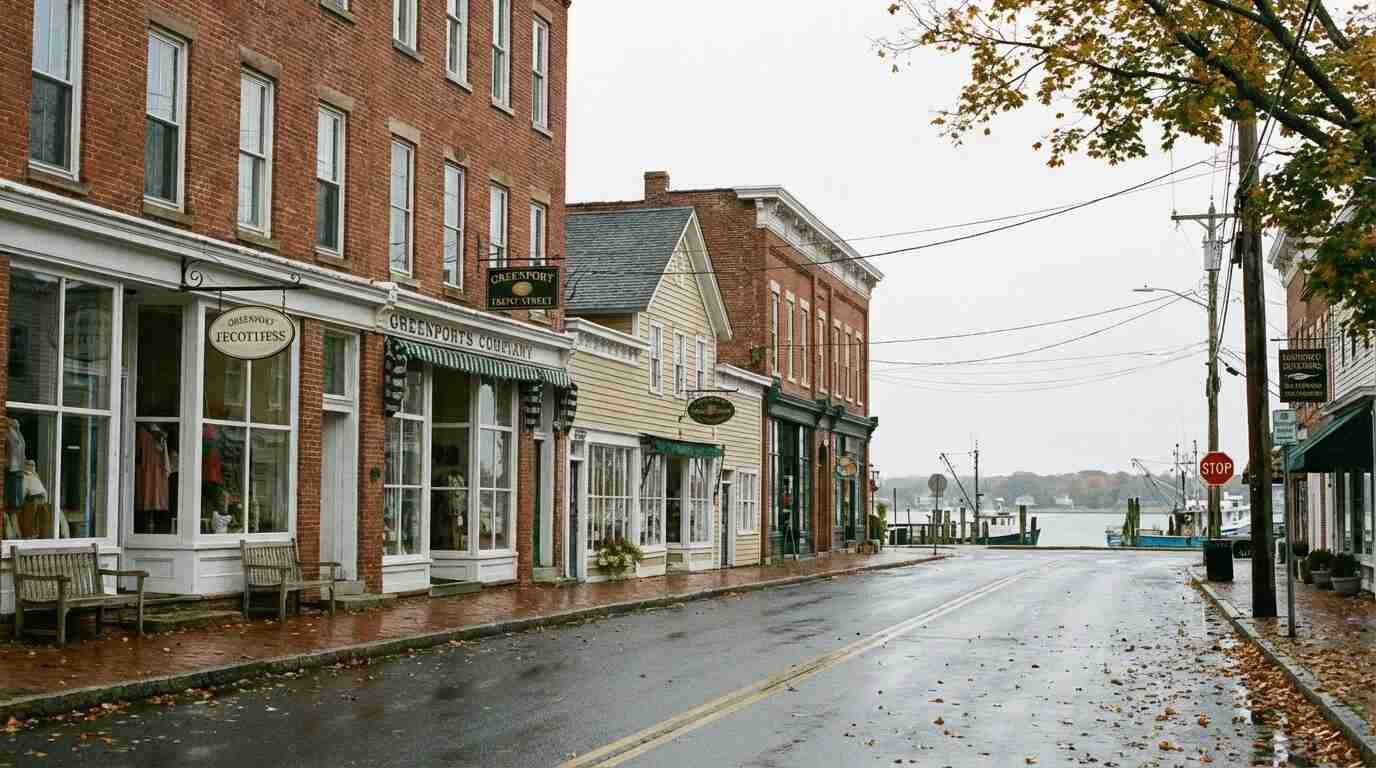
The thing about Greenport is that the bones give it away. Walk the length of Front Street on a Tuesday in October, when the summer crowd has thinned and the village returns to something closer to its actual self, and what you’re looking at — behind the boutique signage, behind the painted facades and the wine-bar lighting — is a working waterfront that has been dressed for another occasion.
I’ve walked that block more times than I can count. As a broker covering the East End, I’ve shown property in and around Greenport for years, and the question I get most often from buyers — particularly from people moving from cities — is some version of: how does a town this small have buildings this substantial? The floors are thick. The ceiling heights are generous by any residential standard. Some of the older structures on the water side show loading-bay proportions, door widths that make no sense for retail. You see remnants of iron hardware at roofline — the ghost of crane mounts, if you know to look for them.
Those buildings weren’t built for boutiques. They were built for an industry that ran on salt water and muscle, and the Sanborn fire insurance maps from the Library of Congress’s Greenport collections — dated 1886 through 1917 — show exactly what was happening on these parcels when the ink dried.
What the Sanborn Maps Show
The Sanborn Map Company surveyed Greenport multiple times beginning in the late 19th century, producing large-scale building-by-building records for the fire insurance industry. What those maps captured was a commercial district organized almost entirely around maritime function. The Front Street and Main Street blocks weren’t a general-purpose downtown. They were the landward infrastructure of a working port.
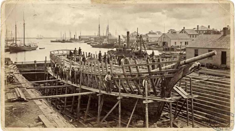
Greenport had been a major whaling port between 1795 and 1859, with 24 to 25 ships operating out of its harbor and over 100 documented voyages. By the standards of the era, that was substantial — Greenport ranked among the more significant whaling ports in the Northeast. Whaling drove a shipbuilding boom, and the shipyards produced over 550 vessels from the early 19th century through World War II. The first documented vessel built in Greenport was the sloop Van Buren, launched in 1834 by Caleb Horton.
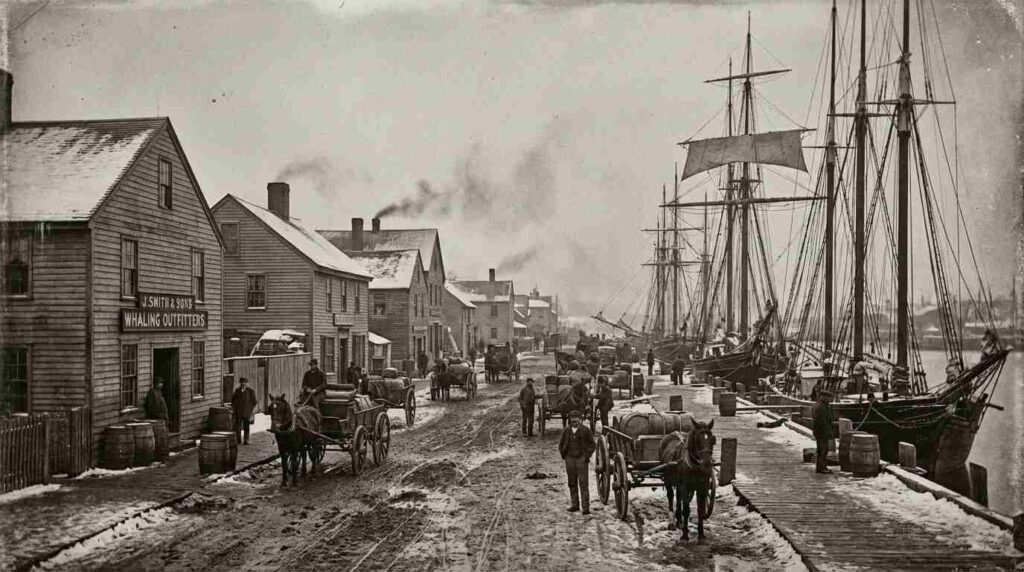
By the time whaling declined in the 1860s — killed off by depleted stocks, the disruption of the Civil War, and the arrival of cheaper petroleum — the village had already built its commercial infrastructure around maritime industry. The buildings on Front Street reflect that layering. Chandleries, cooperages, sail lofts, rope walks, and ship’s chandlers occupied the streetfront. Further back, toward the water, the heavier industrial functions took over: the yards, the rail yard, the menhaden processing operations.
The Sanborn maps record all of it, building by building, with notation of construction materials, floor counts, and original occupancy. For a property historian, the maps are the equivalent of a chain-of-title for the built environment — they tell you not just what a building is, but what it was for.

The LIRR Arrival and What It Changed
The Long Island Railroad reached Greenport on July 27, 1844 — making Greenport the original eastern terminus of the line, the end-point of what was then a New York–to–Boston rail-and-steamship route via Long Island Sound. The station that now houses the East End Seaport Museum was built in 1892, but the rail presence transformed Greenport’s commercial architecture decades before that.
When the railroad arrived, it gave the maritime economy a land connection it hadn’t had before. Farm produce from the North Fork interior could move through Greenport to New York markets. Whale oil and cargo arriving by ship could transfer to rail. The commercial blocks expanded to handle the volume. By 1881, according to village records, 5,350 ships were moored in Greenport harbor in a single year — an extraordinary figure for a village of its size.
The menhaden processing operations that dominated the post-whaling era generated their own building typology: long, low warehouse structures with specific ventilation requirements, built close to the water. Oystering, which peaked in the early 20th century with as many as 14 oyster-processing companies operating simultaneously in the village, added another layer — smaller-scale, more dispersed, but still organized around direct water access.
Each of these industries left a building type. The chandlery needed wide-plan ground floors for rope and tackle storage. The sail loft needed long, open second-floor runs for laying out canvas. The oyster processor needed proximity to the dock and a refrigeration workflow. When those industries declined and the buildings found new tenants, the bones stayed.
Reading the Facades Today
Walk the Greenport historic district as the Stirling Historical Society has documented it, and the clues are visible if you know the vocabulary. Ground-floor door widths on the older Front Street structures often run well beyond what retail requires — those widths accommodated cart access, barrel rolls, and ship’s gear, not foot traffic. Second-floor loading bays have been in-filled or converted, but the proportional ghost of the original opening remains in the facade rhythm. Iron hardware — cleats, ring bolts, mounting plates — appears at intervals that correspond to historic working functions, not decoration.
The Greenport Yacht & Shipbuilding facility, still operating on the waterfront, is the most direct surviving link to the shipyard era. The site dates to the early 19th century; during World War II, the yard employed as many as 1,200 men building minesweepers around the clock. When you look at the adjacent commercial blocks and wonder why the buildings seem overbuilt for their current uses, this is the answer: they were built to scale with an industry that required serious infrastructure.
For buyers looking at commercial property in Greenport’s historic district, this architectural history carries real transactional relevance. A building with a documented Sanborn survey record can support a chain of historical occupancy that affects everything from permitted use to landmark eligibility to renovation scope. The Village of Greenport’s historic district documentation through the Planning Board provides building-by-building records; the Library of Congress Sanborn collection for Greenport is accessible online and free to search.
What you’re reading in those records isn’t nostalgia. It’s provenance. And in the current Greenport market — where the premium on village commercial property continues to grow, driven by tourism, second-home demand, and the wine country corridor it anchors — provenance translates directly into price.
One way to understand how a working waterfront becomes a real estate premium is to look at what happened in Sag Harbor, where the decline of the whaling industry directly shaped the lot sizes and walkability that make the village valuable today. That story is worth reading before buying anywhere on the East End. For the broader picture of how Long Island’s menhaden fishing economy shaped the North Fork’s coastal ecology — and what that means for buyers near the water — the post on bunker fishing off Montauk covers the same industrial legacy from the sea side.
- Why Sag Harbor’s Whaling Decline Created the Exact Lot Sizes That Make It the Most Walkable Village on the East End Today
- Bunker Fishing Off Montauk: The Industrial Menhaden Fleet That Worked These Waters for a Century
- The Hampton Bays Marina That Became a Cold War Listening Post — and the Waterfront Parcels That Still Show Up Strange on Deed Searches
Real estate markets change. For current listings and market data, contact Pawli at Maison Pawli.
This is for informational purposes only — consult a licensed attorney or financial advisor for your specific situation.
- Library of Congress, Sanborn Fire Insurance Map Collection — Greenport, NY, 1917 edition: https://www.loc.gov/item/sanborn05961_006/
- Library of Congress, About the Sanborn Maps Collection: https://www.loc.gov/collections/sanborn-maps/about-this-collection/
- Suffolk Times Archives, “Greenport at 175: A Look at the History of Business Here” (2013): https://suffolktimes.archive.timesreview.com/2013/06/greenport-at-175-a-look-at-the-history-of-business-here/
- Dan’s Papers, “Greenport: A Whale of a Waterfront Destination” (2021): https://www.danspapers.com/2021/10/salute-to-greenport-village/
- Grokipedia, “Greenport, Suffolk County, New York”: https://grokipedia.com/page/Greenport,_Suffolk_County,_New_York
- Northforker, “Of Fathers and Sons and Shipyards” (2026): https://northforker.com/2026/03/of-fathers-and-sons-and-shipyards-a-view-into-greenports-storied-working-waterfront-with-anders-langendal-sons-boatbuilders/
- Railroad Museum of Long Island, “The Greenport Historic Transportation District”: https://www.rmli.org/visiting-us/the-greenport-historic-district/
- Greenport Village Historic District Walking Tour (Stirling Historical Society / Village of Greenport): https://greenportwalkingtour.org/walking-tour.pdf