The Block That Time-Locked: Why Port Jefferson Village’s Walking Culture Survived When Every Town Around It Didn’t
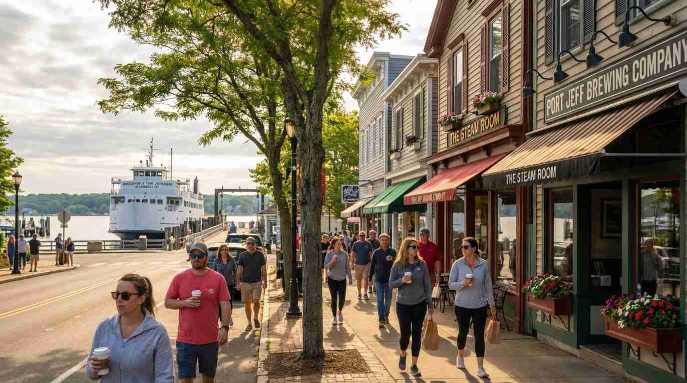
Pull into Port Jefferson on a Saturday morning and something happens that doesn’t happen in most of Suffolk County: you feel the urge to park the car and walk. The harbor comes into view. There’s a ferry at the dock. Someone is opening a café. The street narrows, buildings come close, and the geometry of the place makes the rest of the town feel immediately legible — like somewhere you could figure out on foot, which is another way of saying like somewhere you could actually live rather than just store yourself between commutes.
I have clients who come to Port Jefferson specifically because of that feeling, and I always make a point of naming it plainly: what they’re responding to is not charm in some vague aesthetic sense. It’s walkability. It’s the presence of a real pedestrian environment — continuous sidewalks, buildings set close to the street, ground-floor uses that serve people on foot, a street scale that makes walking feel natural and crossing feel manageable. Port Jefferson village has all of these things. The towns immediately surrounding it largely don’t.
That divergence is not geography. It’s planning history. And it almost went the other way.
What Walkability Actually Measures
Before getting to the history, a quick note on how walkability is actually assessed — because “walkable” gets used loosely in real estate contexts to mean everything from “there’s a sidewalk somewhere” to “you could theoretically walk to a grocery store if you wanted to.”
Walk Score, which uses a public algorithm to rate pedestrian access to amenities within a walkable radius, gives Port Jefferson village a score in the low-to-mid 70s — “very walkable” by their rubric, meaning most errands can be accomplished on foot. Port Jefferson Station, roughly two miles south along Route 112, scores in the 40s — “car-dependent.” Coram, a few miles to the east along Route 25, scores in the 30s.
Those gaps are meaningful. They correspond to real differences in daily life: whether you need a car for a prescription pickup, whether children can walk to a store, whether you can age in place without surrendering your independence to automobile access. They also correspond to real differences in property premium — walkable urban environments consistently command higher per-square-foot values than car-dependent suburban equivalents, a pattern documented across markets nationally by researchers at the University of Arizona and elsewhere.
The 1970s Fight That Didn’t Make Headlines
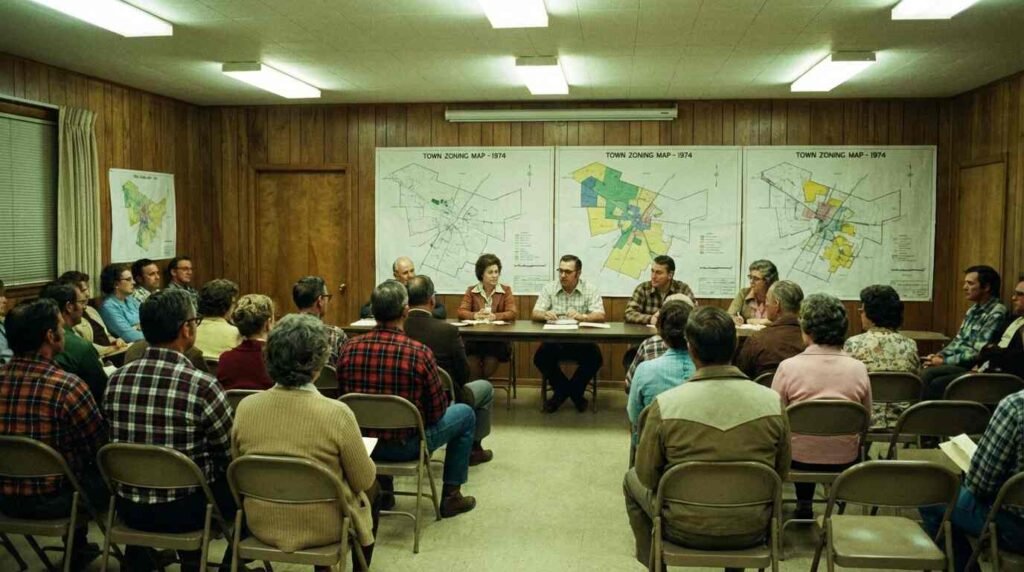
Port Jefferson’s walkable village core did not survive the postwar suburban expansion by accident. It survived because of a series of zoning decisions made by the Village of Port Jefferson Planning Department and supported, sometimes contentiously, through the 1970s and into the 1980s.
The pressure was real. The same forces that suburbanized downtown areas across Long Island — chain retailer expansion, parking requirement mandates, the assumption that the automobile was the only legitimate planning unit — came to Port Jefferson. There were proposals, documented in the Brookhaven Town zoning variance record, to expand parking footprints in the village commercial core, to rezone certain blocks for uses that would have increased vehicle access and reduced ground-floor retail continuity. Some of those proposals passed. More of them were denied or modified.
The critical variable appears to have been the ferry. The Port Jefferson–Bridgeport ferry, which has operated continuously since 1883, provided an economic anchor that made foot traffic commercially valuable in a way it wasn’t in inland communities. A ferry terminal generates pedestrian demand — passengers arriving, departing, waiting, spending money. Businesses near the terminal learned early that their customers arrived on foot, and the commercial logic of the village reinforced pedestrian orientation accordingly.
The Port Jefferson Free Library’s Emma S. Clark local history room holds records of village planning debates from this period. What emerges from those records is a community that had a genuine disagreement about what it wanted to be — some voices arguing for the kind of accessibility improvements that, elsewhere, translated into parking lots and lane expansions; other voices arguing for the preservation of the village fabric that was, by the 1970s, already being recognized as economically and culturally valuable. The latter voices won enough of the arguments to matter.
The Comparison That Clarifies Everything
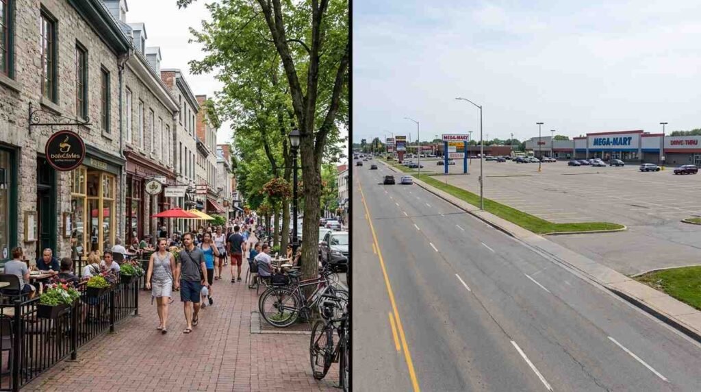
Coram and Port Jefferson Station are the right comparison cases because they represent what Port Jefferson village could have become — not because they failed at anything, but because they followed the development logic that was dominant during the same postwar decades and produced a different result.
Port Jefferson Station grew substantially in the postwar era, oriented around Route 112 and the LIRR station but without the village-scale commercial zoning that Port Jefferson village maintained. The result is a community with good transit access, reasonable housing prices, and a daily life organized almost entirely around the car. The LIRR station serves commuters; it does not anchor a pedestrian district. The distance between the platform and any meaningful commercial activity involves crossing roads that were designed for vehicle throughput.
Coram developed along Route 25 in the standard postwar pattern: strip plazas, big-box anchors, parking lots between the road and the building face. It is functional in the way that most of Long Island is functional — you can get everything you need there, as long as you have a car. What it doesn’t have is the self-reinforcing pedestrian logic that makes Port Jefferson village feel like a place rather than a zone.
The difference is legible in business longevity, too. The Port Jefferson Free Library local history collection documents Main Street businesses that have operated in the same location for decades — not all of them, and there has been turnover, but the retention rate of independent businesses in the village core is notably higher than in the strip-commercial corridors of neighboring communities. This is consistent with research on pedestrian districts nationally: foot traffic reduces the customer acquisition cost for small businesses, which in turn supports their survival relative to car-dependent competitors who depend on billboard visibility and drive-by recognition.
What It Means to Buy Here
I want to be direct about the real estate dimension of this, because it’s where the history becomes practical.
Port Jefferson village commands a premium. Not just for waterfront — though waterfront in the harbor is its own conversation — but for the village center itself. A home within walking distance of the ferry dock, the village commercial strip, the harbor, is priced at a premium over a comparable home in Port Jefferson Station or Coram, and that premium has been durable.
Some of that premium is views and character, the things that show up in listing photographs. But a significant portion of it is walkability infrastructure — the sidewalks, the ground-floor uses, the street scale — that represents decades of accumulated planning decisions. You are, when you buy in Port Jefferson village, partly buying the result of the 1970s zoning fight. You’re buying the argument that was won.
What I tell clients who are weighing Port Jefferson against less expensive neighboring communities is this: run your own numbers on car dependency. A second car, in most American households, costs somewhere between $8,000 and $12,000 per year when you account for purchase, insurance, fuel, and maintenance. If living in Port Jefferson village allows a household to go from two cars to one, the walkability premium may pay for itself in relatively short order — and it tends to hold its value in ways that other premium-generating features don’t always do.
There is also the less quantifiable dimension. The ability to walk to things — to walk to a restaurant without planning, to walk to the water without a production, to run into a neighbor at the hardware store rather than ordering from a screen — is a quality-of-life factor that shows up in surveys of residential satisfaction consistently. It’s the thing people describe when they say a town feels alive. Port Jefferson village has it. The places around it, mostly, don’t. That didn’t happen by accident, and it won’t sustain itself without continued intention.
The Unfinished Work
Port Jefferson village is not a solved problem. There are blocks at the edges of the commercial district where the pedestrian environment deteriorates — where the sidewalk disappears, where a parking lot interrupts the building line, where the street scale shifts toward the arterial. There are ongoing debates about traffic, about ferry terminal access, about the balance between resident parking and visitor accommodation. The village has survived its 1970s crisis; it is now navigating the slower pressures of a community that has become desirable enough to attract the kind of development interest that desirable places always attract.
The question Port Jefferson is asking now is the same question that Cold Spring Harbor is asking and that Huntington’s station area is beginning to ask: what does preservation actually require? Not of buildings, necessarily — though that’s part of it — but of the pedestrian logic, the street scale, the ground-floor commercial continuity that makes a village feel like a village rather than a themed version of itself.
The 1970s planners who held the line on Port Jefferson’s zoning did not know they were doing something historically significant. They were making practical arguments about traffic and parking and commercial viability, one variance hearing at a time. The accumulation of those decisions is what you see now when you park the car on Saturday morning and feel the pull of the harbor. That pull is worth protecting. It always was.
Real estate markets change. This post reflects conditions as of April 2026. For current listings and market data, contact Pawli at Maison Pawli.
You Might Also Like:
- The Stroad That Ate Jericho Turnpike: How One Road Fragmented Five North Shore Communities
- Tonnage and Tenon: How Port Jefferson’s Shipwright Tradition Crossed into Furniture Joinery
- Selling History at Market Price: How to Price a North Shore Pre-War Home
Sources:
- Walk Score public data — https://www.walkscore.com (verify current scores before publishing)
- Village of Port Jefferson Planning Department records
- Brookhaven Town Clerk’s Office — historical zoning variance records, 1970s–1980s
- Port Jefferson Free Library, Emma S. Clark local history room, Port Jefferson, NY
- Leinberger, Christopher B. The Option of Urbanism: Investing in a New American Dream. Island Press, 2008.
- University of Arizona / Smart Growth America research on walkable urban places and property values — verify most current study before citing