How to Read a Waterfront Lot Survey Before You Make an Offer

There’s a moment that happens at nearly every waterfront showing I do on the North Shore — the buyer is standing at the edge of the yard, looking out at the Sound or the harbor or the creek, and they point somewhere into the water and ask me: “Where exactly does my property end?”
It’s a fair question. It’s also one that no one at the table — not the listing agent, not the seller, sometimes not even the attorney — can answer cleanly without the survey in hand. And even then, for waterfront parcels, the survey is only the beginning of the conversation.
Before you make an offer on any waterfront property on Long Island’s North Shore, you need to understand what a lot survey actually shows, what it deliberately doesn’t show, and why the standard residential survey you’re used to seeing at a closing falls short when the lot line meets the water.
What a Survey Is (and Isn’t)
A property survey is a licensed surveyor’s measurement and mapping of a parcel’s legal boundaries. For a standard inland lot, the survey shows the four corners of the property, the dimensions of each boundary line, the location of structures, easements, and encroachments, and — if done well — the location of any recorded rights-of-way or utility lines.
For a waterfront lot, all of that applies. But waterfront surveys carry a set of additional complications that don’t appear on the form at all, and that licensed surveyors are required to note but are not always required to interpret for you. The interpretation is your job — or your attorney’s.
The survey tells you where the lines are. It does not tell you what those lines mean for what you can build, what you can put in the water, or how those lines will shift as the shoreline changes. That’s the part buyers miss.
The Mean High Water Mark and Why It Controls Everything
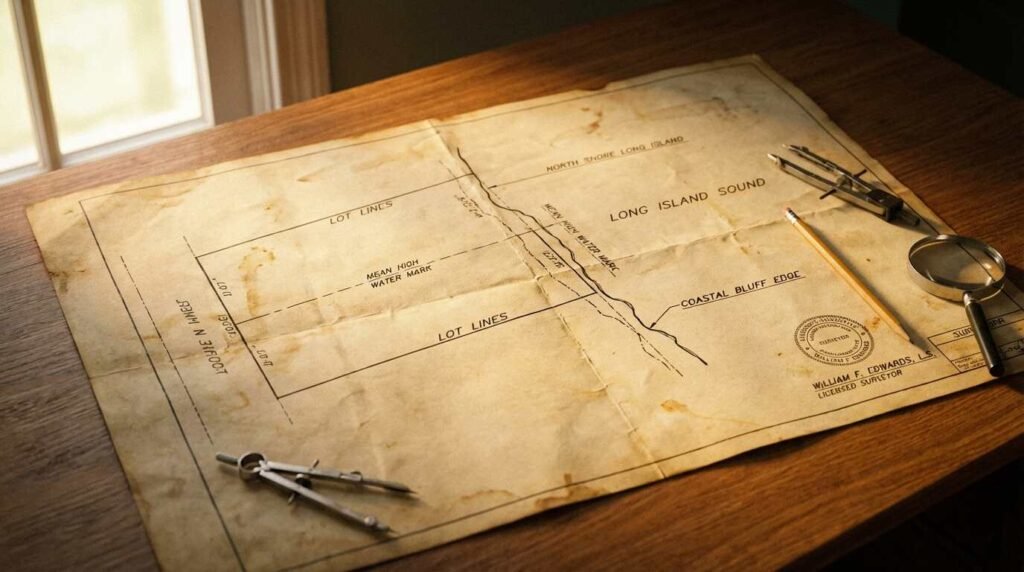
On Long Island’s tidal waters — the Sound, the harbors, the bays, the inlets, the estuaries — the legal boundary between private property and public waterway is typically the mean high water mark (MHWM). This is the average of all the high tide readings taken over an eighteen-year tidal epoch, as established by NOAA’s National Tidal Datum Epoch.
What this means in practice: the land above mean high water is yours (subject to easements). The land below it — the intertidal zone, the foreshore, the bottom — belongs to New York State, held in the public trust. You may own the property down to the waterline as defined on a given day, but the state claims the land that the tide periodically covers and uncovers.
When you look at a waterfront survey, the mean high water mark should be clearly notated as a separate boundary line, distinct from the lot’s upland boundary. On older surveys — and there are a lot of them on the North Shore, particularly in communities like Nissequogue, Centerport, and Cold Spring Harbor, where properties haven’t changed hands in decades — this notation is sometimes missing, imprecise, or based on a tidal datum that is now outdated. A shoreline that has eroded since the survey was drawn may now sit in a very different place relative to the MHWM than the survey suggests.
This is not a minor discrepancy. The MHWM determines where your dock can legally begin. It determines where DEC jurisdiction kicks in for any construction or land disturbance. It determines whether that beautiful stretch of beach you’re picturing as yours is actually intertidal land that any member of the public can walk on during low tide.
I always ask for the most recent survey available, and I always ask how old it is. Anything more than ten years old on an eroding or accreting shoreline should be resurveyed before closing.
Reading the Lot Lines on a Waterfront Parcel
Waterfront lot lines don’t always run perpendicular to the water. On the North Shore — particularly in coves, harbors, and along irregular shorelines — lot lines frequently angle into the water, following the original subdivision geometry from the 19th or early 20th century. This produces wedge-shaped lots, where the upland width is narrower or wider than the waterfront footage, and where two neighboring lots may have overlapping or ambiguous claims to a particular stretch of shoreline or submerged land.
What to look for on the survey:
Lot lines extending into the water. Some North Shore deeds convey ownership of submerged land out to a specified distance — often to the thread of the channel, or to the town- or county-defined navigation line. If the survey shows lot lines extending below the MHWM, you need to know exactly what rights those underwater acres carry and who has said so in a legal document.
Shared boundary lines. In older communities, a lot line that extends into tidal water may be shared — meaning two adjacent property owners have overlapping riparian claims that have never been formally adjudicated. This isn’t unusual on the North Shore. It is something your attorney needs to review before you close.
Tidal wetlands delineation. The survey may or may not show the boundary of any state-delineated tidal wetlands on the parcel. If it doesn’t, and if there is marsh, spartina, or wet vegetation anywhere on the lot, you need a separate tidal wetlands delineation conducted by a licensed environmental professional before you understand the true developable envelope of the property. The DEC tidal wetlands permit nobody mentions at the showing is directly relevant here — I covered the full regulatory picture in that post.
Erosion setbacks and bluff lines. On North Shore properties with bluffs — and there are many, from Lloyd Neck through Port Jefferson and out toward Mount Sinai — the survey may note a coastal erosion hazard area (CEHA) boundary established by the DEC. This line determines how close to the bluff edge you can build. It also tends to move inland over time as erosion progresses, which means a CEHA line drawn fifteen years ago may no longer reflect current conditions. I wrote about the erosion question specifically for buyers of North Shore bluff homes — if the property you’re considering has a bluff, read that post before you make any assumptions about future stability.
The Difference Between What You Own and What You Can Use
This is the conversation I find myself having most often, and it’s the one buyers least expect to need.
You can own submerged land — meaning you hold title to it in your deed — and still be legally prohibited from using it in ways that would seem obvious. You can own to the thread of the channel and still be unable to build a dock without a DEC permit and a Town of [X] wetlands permit and potentially a U.S. Army Corps of Engineers permit. You can own the intertidal zone and still have no legal right to exclude the public from walking it at low tide under New York’s public trust doctrine.
The survey shows you the geometry of what you own. It does not tell you what you’re allowed to do with it.
The rights questions — dock rights, mooring rights, the ability to dredge, the ability to place a float — are separate from title questions. They’re governed by state environmental law, local town code, and in some cases federal navigation law. And they don’t always run with the land in the way a buyer assumes they do. I cover the specific distinctions between dock rights and mooring rights in my companion post on what North Shore waterfront buyers need to settle before closing — [note: this post will publish simultaneously, link to activate post-publish].
The practical upshot: never assume that because the previous owner had a dock, you will have a dock. Confirm that the permit is active, transferable, and not contingent on conditions the property no longer meets.

What a Standard Residential Survey Misses
The standard survey form — the kind you see at every inland residential closing on Long Island — is not designed for waterfront parcels. It will show you the lot lines, the structures, and any recorded easements. It will typically not show you:
- The mean high water mark as a separately surveyed line
- Tidal wetlands delineation
- Coastal erosion hazard area boundaries
- Any submerged land grant or underwater ownership claim extending beyond the standard shoreline
- The location of structures in or over the water relative to regulatory setbacks
- Storm damage, erosion, or accretion that has changed the actual shoreline position since the last survey
For a waterfront property, you want a survey that specifically addresses all of these elements. Ask your attorney what the survey scope includes before ordering it. And if the seller has a survey on file that doesn’t address these elements, don’t treat it as authoritative for your transaction.
The cost of a waterfront survey is higher than a standard residential survey — often meaningfully so. That cost is not negotiable. It is a prerequisite.
Questions to Ask Before You Close
My standard checklist for waterfront survey review, which I give every buyer I work with on North Shore waterfront purchases:
- How old is the survey? Has the shoreline changed materially since it was drawn?
- Is the mean high water mark specifically delineated and dated?
- Does the deed convey any submerged land? If so, to what extent and what rights attach?
- Is there a tidal wetlands delineation on file with the DEC? Does it match the survey?
- Is there a coastal erosion hazard area boundary noted? When was it last surveyed by the DEC?
- Are any structures — docks, floats, bulkheads, ramps — located within state-regulated areas? Are their permits current and transferable?
- Are there any shared lot lines with adjacent waterfront owners that have not been formally resolved?
- Does the survey show any encroachments by neighboring property onto the waterfront area — a dock extending over the lot line, a neighbor’s boat float in your underwater territory?
If you’re relying on flood insurance as part of your mortgage underwriting — and on the North Shore you almost certainly will be — the survey will also be used to establish the elevation certificate your insurer requires. I covered what FEMA maps don’t tell you about North Shore flood risk in a previous post; that piece pairs directly with this one if you’re building out your due diligence file.
The Bulkhead Question
A word specifically about bulkheads, because they come up at almost every North Shore waterfront showing I do.
A bulkhead is a retaining structure that holds the upland in place along the shoreline. On the survey, it shows up as a line — usually at or near the MHWM. But the survey will typically not tell you: how old the bulkhead is, what material it’s made of (timber, vinyl, steel sheet pile), whether it’s permitted, whether the permit is expired, whether it’s failing, or what replacing it will cost.
Bulkheads on Long Island’s North Shore range from relatively new vinyl installations to timber structures that are fifty, sixty, seventy years old. A failing bulkhead is an expensive problem — I wrote specifically about the brutal economics of North Shore bulkheads for buyers who need to understand what they’re taking on. That post is required reading before any North Shore waterfront offer.
If the survey shows a bulkhead, treat it as a red flag to investigate further, not as evidence that the erosion problem has been solved.
Pawli’s Bottom Line
I’ve helped a lot of buyers buy waterfront on the North Shore. And the deals that go sideways — or the buyers who end up surprised three years later — are almost always the ones who treated the survey as a box to check rather than a document to read.
Waterfront property is not like any other real estate. The value proposition is real. The complexity is also real. A parcel that looks bounded and clear from the dock can be layered with overlapping jurisdictions, ambiguous ownership claims, and physical changes that no one at the table has fully accounted for.
Get the right survey. Get the right attorney. Ask all the questions before the contract is signed, not after.
The Sound will still be there when the due diligence is done. The view isn’t going anywhere. The property rights, though — those need to be exactly what you think they are before you close.
This post is for informational purposes only and does not constitute legal or financial advice. Consult a licensed real estate attorney for guidance on your specific transaction.
Real estate markets change. For current listings and market data, contact Pawli at Maison Pawli.
You Might Also Like
- North Shore Bluff Homes and the Erosion Question: What Buyers Need to Know
- Holding Back the Sound: The Brutal Economics of North Shore Bulkheads
- The DEC Tidal Wetlands Permit Nobody Mentions at the Showing
Sources
- New York State Department of Environmental Conservation — Tidal Wetlands Program: https://www.dec.ny.gov/lands/4717.html
- NOAA Tidal Datums and Tidal Datum Planes: https://tidesandcurrents.noaa.gov/datum_options.html
- New York State Department of State — Coastal Erosion Hazard Areas: https://www.dos.ny.gov/opd/programs/consistency/cmp/coastal_erosion.html
- U.S. Army Corps of Engineers, New York District — Section 404/10 permits: https://www.nan.usace.army.mil/Missions/Regulatory/
- New York Public Trust Doctrine — relevant case law: Carstensen v. Bd. of Trustees of Village of Bridgehampton, 2004 (verify citation with attorney)