The Stony Brook Mill Pond’s Buried Shoreline: How University Geoarchaeologists Are Reconstructing a Pre-Colonial Landscape Beneath a Tourist Landmark
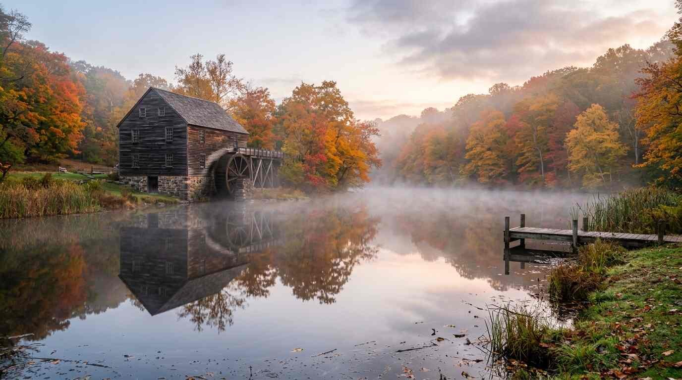
The mill pond at Stony Brook Village is one of those views that registers as timeless. The wooden mill, the duck pond, the manicured village green — it reads like a stage set designed to look exactly like it has always looked. That is, in a sense, exactly what it is: the Ward Melville Heritage Organization has managed Stony Brook Village Center since the 1940s as a designed historic environment, curated for continuity. The aesthetic is deliberate. The timelessness is constructed.
Which makes what is happening in the sediment beneath the pond — and in the tidal channels that connect it to Porpoise Channel and, ultimately, to the Sound — all the more interesting. Stony Brook University’s Department of Anthropology has produced faculty with active research interests in historical and environmental archaeology on Long Island, and the Three Village area, sitting within the documented territory of the Setalcott Algonquian people, has been a productive zone for subsurface investigation. What the sediment cores pulled from the mill pond basin and adjacent estuary contain is a record of a landscape that predates Melville’s vision by millennia — and that looks nothing like the village center above it.
The Setalcott Baseline
The Ward Melville Heritage Organization’s historical records document the colonial and post-colonial history of the Stony Brook mill and its immediate surroundings in considerable detail. What they cannot document is the landscape that the colonial-era mill was built into — the shoreline configuration, the estuary morphology, the coastal landform that existed before European modification of the watercourse.
That is what the sediment cores recover.
Published research by Stony Brook University Department of Anthropology faculty, alongside work from the New York State Museum on Long Island Algonquian archaeology, establishes the Setalcott occupation of the Three Village area as sustained and geographically specific. The Setalcott people used the estuarine zone around Porpoise Channel and the sheltered coves along this coastline for fishing, shellfishing, and seasonal habitation. The SHPO site inventory for Brookhaven Town contains site records documenting Setalcott-era material deposits in the Three Village area — shell middens, fire-cracked rock scatters, isolated ceramic finds — that locate Algonquian land use patterns in the landscape now occupied by the historic village.
What geoarchaeological work in the mill pond basin adds to this picture is dimensional. The sediment core record can reconstruct past shoreline configurations — where the estuary mouth was located before colonial modification, how the tidal flat and salt marsh zones have shifted over time, what the pre-dam hydrology of the Stony Brook watershed looked like before the mill pond was created. That reconstruction provides the environmental context within which the Setalcott use of this landscape makes spatial sense: where the fish ran, where the shellfish beds were, where a canoe could be drawn up onto a protected beach.
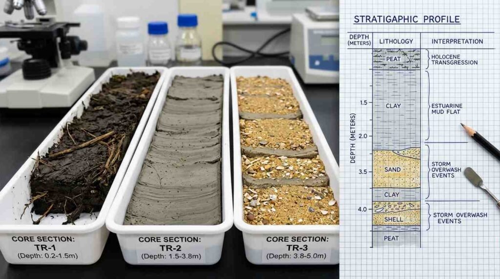
What a Sediment Core Reads
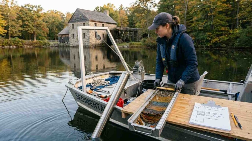
A sediment core from an estuarine environment is a vertical record of environmental change. Reading it requires attention to multiple lines of evidence simultaneously: the physical texture of the sediment (coarse sand suggests high-energy depositional events like storms; fine clay suggests slow, low-energy accumulation); the organic content (pollen, plant macrofossils, and charcoal record vegetation change and fire history); and the biological remains (diatoms, foraminifera, and ostracodes are sensitive indicators of salinity and water depth).
The cores from the Stony Brook mill pond basin and Porpoise Channel contain a pre-dam sediment sequence that extends well below the colonial-era modification horizon. That sequence records the natural depositional history of this estuary from the post-glacial period — when the Long Island Sound coastline was still stabilizing — through the Archaic and Woodland periods of Algonquian occupation, into the contact era and colonial modification.
The colonial modification horizon is itself archaeologically significant. The construction of the mill dam — which created the mill pond by impounding the Stony Brook watershed — is visible in the sediment cores as an abrupt boundary: below the dam, a natural estuarine sequence; above it, the characteristic fine-grained, low-energy deposit of a managed impoundment. The dam is an archaeological feature as well as an engineering one, and its stratigraphic signature in the sediment allows it to be dated and its environmental effects to be measured.
The Ward Melville Paradox
There is an irony embedded in the Stony Brook Village Center story that I find worth naming. Ward Melville’s project was explicitly preservationist — he bought and curated the village to protect it from the kind of commercial development that was consuming communities across Long Island in the mid-20th century. His vision of what Stony Brook should look like was, in its way, an act of conservation.
But the pre-colonial landscape that the geoarchaeological work is reconstructing was not part of his conservation vision. The timeless colonial village aesthetic he created actively suppressed the evidence of the much longer occupation history beneath it — the Setalcott shoreline that the mill pond submerged, the estuary that the dam impounded, the landscape that the colonial settlers themselves had modified before Melville arrived to preserve their modifications.
Preservation is always partial. What gets preserved depends on whose history is considered worth preserving, and in what form. The sediment cores beneath the mill pond are recovering a history that Melville’s preservation program did not — perhaps could not — account for. The collaboration between Stony Brook University researchers and the Ward Melville Heritage Organization on site history is, in this context, a genuinely productive tension: the curated village and the buried shoreline existing in conversation, each making the other more legible.
Three Villages, Multiple Timescales
I work this area regularly. The Three Village market — Stony Brook, Setauket, Old Field — holds value for reasons that are partly architectural, partly school-district, and partly the intangible character of a place that has been carefully maintained over several generations. The Stony Brook neighborhood profile is one of the more stable on the North Shore, and buyers who come here tend to stay.
What the geoarchaeological work adds to that picture is a sense of how deep the stability runs — not just to Melville’s mid-20th century curation, not just to the colonial-era mill, but to the Setalcott use of this estuary that preceded everything the village center commemorates. The pre-colonial landscape is not gone. It is underneath. The mill pond’s surface is placid, the ducks are present, the mill wheel turns. The sediment beneath it is recording a much longer duration.
That is not a marketing point. It is simply what this place is — and knowing it changes how you look at the mill pond, and the village around it, and the North Shore history that everything here is embedded in.
Sources
- Stony Brook University Department of Anthropology — faculty research: https://www.stonybrook.edu/commcms/anthro/
- Ward Melville Heritage Organization historical records: https://www.wmho.org
- New York State Museum — Long Island Algonquian archaeology: https://www.nysm.nysed.gov/research-collections/anthropology
- SHPO site inventory for Brookhaven Town: https://www.nysparks.com/shpo/
Stony Brook is one of the communities profiled in my North Shore Long Island Neighborhoods: The Insider’s Guide to Where to Live, which walks through the North Shore neighborhood by neighborhood — the Three Village district, the university’s influence, commute dynamics, and what each community actually feels like to live in.