The Forgotten Developer Who Platted the North Fork: How 19th-Century Land Subdivisions Still Govern Modern Property Lines
Somewhere in a Suffolk County surveyor’s file is a plat map drawn in the 1880s that still determines where your fence can go in Cutchogue.
That’s not a metaphor. It’s the operational reality of buying property on the North Fork of Long Island, where the lot dimensions, road alignments, and subdivision patterns governing modern parcels were largely established by a generation of 19th-century speculators and surveyors whose names have been almost entirely forgotten. The people who platted Mattituck and Peconic and Southold are not commemorated on plaques. Their filing dates don’t come up in listing descriptions. But their decisions — made when the railroad was new and the land was cheap — are embedded in every deed that transfers on the North Fork today.
I think about this every time a buyer asks me why a North Fork parcel has an irregular western boundary, or why the road setback on a particular hamlet lot runs at an unexpected angle to the street. The answer is almost always the same: pull the original plat. Not the current survey. The original plat, filed in the Suffolk County Clerk’s historical plat books, at the time the hamlet was first subdivided.
The Railroad Triggered Everything
The Long Island Railroad reached Greenport on July 27, 1844, completing a 94-mile run from Brooklyn in three and a half hours. The original purpose of the line was not to serve Long Island at all. It was designed as part of a New York–to–Boston route, with passengers transferring at Greenport to a steamship across Long Island Sound to Stonington, Connecticut. That intermodal logic collapsed within a few years when an all-land route through Connecticut opened in 1848, sending the LIRR into bankruptcy.
What the railroad’s failure as a Boston route accomplished was the opening of the North Fork to land speculation. The line ran straight down the middle of the island, bypassing the established communities on the north and south shores, but as Kenneth Jackson documented in Crabgrass Frontier — his study of suburban development patterns across American history — railroad access consistently triggered subdivision activity, even when the original economic rationale for the line had dissolved. The pattern holds on the North Fork with particular force. The same LIRR main line that failed to capture the Boston trade ended up defining the development corridor that still structures the East End.
Each hamlet with a station — Riverhead, Mattituck, Cutchogue, Southold, Greenport — became a node of land speculation activity in the decades following 1844. The speculators and surveyors who filed those subdivision plats were typically not local landowners. They were investors, often from New York City, who recognized that railroad access had just transformed agricultural acreage into something with urban connectivity and therefore urban-market value. They hired surveyors, drew grids, filed plat maps with the Suffolk County Clerk, and began selling lots against a landscape that had previously traded only in whole farm parcels.
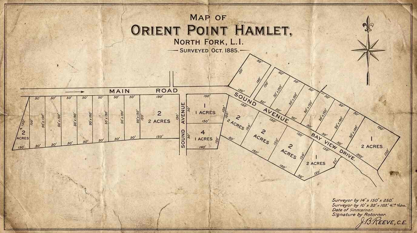
What a Plat Map Actually Records
A plat is a surveyed map of a subdivision — the legal document that establishes lot boundaries, road dedications, easements, and the dimensional rules that will govern every future transfer on those parcels. Once filed and accepted by the county, a plat becomes part of the permanent public record. The lot lines it establishes don’t disappear when the ownership changes. They don’t get renegotiated when a farmhouse is torn down or a vineyard gets planted over a potato field. They run with the land, encoded in the chain of title, until a formal lot-line adjustment or subdivision amendment changes them.
The Suffolk County Clerk’s historical plat book collection holds the original filings for the North Fork hamlets — the plats drawn by the surveyors hired by the 19th-century speculators who laid out the grids. The filing dates cluster in the decades following the railroad’s arrival, tracking the investment activity that the LIRR triggered even as the original NY–Boston rationale for the line evaporated.
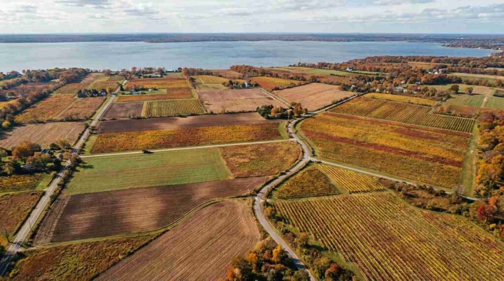
What those plats show is, in many cases, a grid designed for a very different land use than what the North Fork became. The speculators expected the railroad to drive residential and commercial development along the classic American suburban pattern — smaller lots, village centers, walkable density. In many hamlets, that development happened partially and then stopped, leaving behind original plat dimensions that no longer correspond to how the land is actually being used. A parcel that was platted as a standard village lot in the 1870s may now sit in the middle of what is functionally agricultural land, its original dimensions intact in the plat record even as the surrounding acreage has been consolidated or preserved under farmland protection programs.
Why This Matters When You’re Buying
Two categories of buyers on the North Fork should be pulling original plat maps before they sign anything.
The first category is anyone buying agricultural or mixed-use acreage — particularly parcels in the wine country corridor between Riverhead and Orient. The relationship between the original subdivision plat and any subsequent farmland preservation easement is not always clear from the current survey alone. Suffolk County has enrolled significant acreage in development rights purchase programs since the 1970s, and the easements attached to those programs run with the land regardless of how the property has been resurveyed or reconfigured since. The plat map tells you how the parcel was originally constituted; the easement record tells you what use restrictions were imposed and when. Both matter.
The second category is anyone buying in a historic hamlet — Cutchogue, Southold, Mattituck, Peconic — where the lot is small and the neighbors are close. The original plat may show easements, road dedications, or shared-access provisions that don’t appear in the current deed description but are still legally operative. I’ve seen buyers discover, post-contract, that a boundary line they assumed was settled runs through a shared-access strip that was platted in the 1880s and never formally released. That kind of discovery doesn’t kill a deal, but it should have been surfaced earlier — and it would have been, if someone had pulled the original plat before the offer went in.
The Suffolk County Clerk’s historical plat books are publicly accessible, and the records office in Riverhead maintains archives going back to the 19th century. For older plats, the material can also be cross-referenced against USGS historical maps and the 1930s-era aerial photography surveys that the USDA conducted across Long Island as part of agricultural assessment programs — the same surveys that documented the potato farming geography that the wine industry later converted.
The 19th-century surveyors who laid out the North Fork’s subdivision grids were not thinking about vineyards, farmland preservation, or the second-home market. They were thinking about railroad access and lot sales. But the grids they drew are the grids we’re still buying and selling within, a hundred and fifty years later. The forgotten developers who platted the North Fork left behind a legal infrastructure that shapes every transaction in the wine country corridor today. It’s worth knowing their work, even if nobody remembers their names.
For buyers navigating the legal terrain of Long Island property history more broadly, the post on restrictive covenants and how they’ve shaped neighborhood character across the island covers a closely related set of title research issues. And for anyone looking at East End waterfront parcels where dock rights, riparian boundaries, and historical easements intersect, the post on East End dock rights and the legal ambiguity around waterfront property lines is essential reading before you close.
- The Covenant in the Deed: How Restrictive Covenants Shaped Long Island Neighborhoods
- Where Does Your Property Actually End? The Legal Swamp of East End Dock Rights
- The Block That Time-Locked: Why Port Jefferson Village’s Walking Culture Survived When Every Town Around It Didn’t
Real estate markets change. For current listings and market data, contact Pawli at Maison Pawli.
This is for informational purposes only — consult a licensed attorney or financial advisor for your specific situation.
- Wikipedia, “History of the Long Island Rail Road” — LIRR completion to Greenport, July 1844: https://en.wikipedia.org/wiki/History_of_the_Long_Island_Rail_Road
- Railroad Museum of Long Island, “The Greenport Historic Transportation District”: https://www.rmli.org/visiting-us/the-greenport-historic-district/
- Kenneth Jackson, Crabgrass Frontier: The Suburbanization of the United States (Columbia University Press, 1985) — railroad-subdivision pattern context
- Greenport Station, Wikipedia — LIRR terminal history and 1844 opening: https://en.wikipedia.org/wiki/Greenport_station
- Suffolk County Clerk Historical Plat Book collection — Southold Town records, publicly accessible: https://www.suffolkcountyny.gov/Departments/CountyClerk
- Long Island Sustainable Winegrowing, Soil Overview — glacial outwash plain and North Fork terroir: https://www.lisustainablewine.org/our-soil
- Guided Wino, “History of Long Island Wine Country”: https://guidedwino.com/regional-wine-education/history-of-long-island-wine-country