The Road to Ani: Chasing a Lost Medieval Capital on the Turkish-Armenian Border
It was once home to 100,000 people — larger than London, Constantinople, and Paris at its peak. Today the wind moves through it alone.
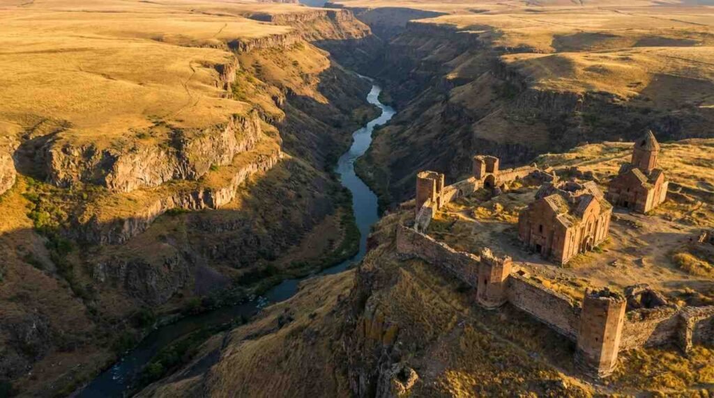
The road to Ani from Kars is forty-five kilometers of flat, open steppe, the Anatolian plateau at its most unmediated: treeless, brown in winter and yellow in late summer, the sky enormous above it, the horizon producing occasional villages that appear and recede without distinguishing themselves. Then the ground drops away at a ravine, the Akhurian River gorge opens below you, and Ani is there — on the other side, the Turkish side, its walls and towers and cathedral ruins standing in a silence that has accumulated for seven centuries.
What Ani Was
The Bagratid Armenian kingdom established Ani as its capital in 961 AD, moving the seat of power from Kars to a city that, by the early eleventh century, had grown into one of the great urban centers of the medieval world. The population estimates — 100,000 to 200,000 at peak — are contested by scholars, as medieval population figures always are, but the physical extent of the city is not contestable: the walls enclosed an area of approximately 1.5 square kilometers, organized around a grid of streets, markets, churches, caravanserais, palaces, and bath complexes whose remains are still readable today.
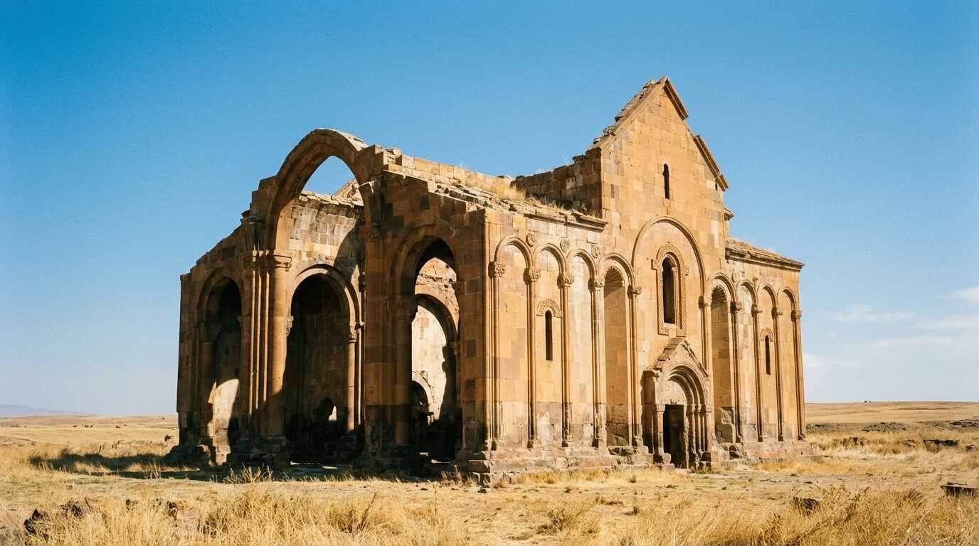
The academic work of Robert Edwards on Armenian architecture documents what made Ani architecturally significant beyond its scale: the Bagratid builders developed a distinctive building vocabulary that synthesized Byzantine, Islamic, and indigenous Armenian traditions into something that had not existed before and would not exist in the same form again. The Cathedral of Ani, begun in 989 and completed by architect Trdat — who also repaired the Hagia Sophia’s dome after a 989 earthquake — is considered the finest surviving example of medieval Armenian religious architecture. Its nave, though roofless, is still standing, the pointed arches of its windows articulating a structural logic that predates their appearance in Western European Gothic by over a century.
The Seljuk Turks captured Ani in 1064, an event described in the chronicles of Sibt ibn al-Jawzi with explicit reference to the scale of the destruction. The city was transferred between powers — Mongol, Georgian, various Turkic dynasties — through the 13th and 14th centuries, when earthquakes and the disruption of the trade routes that had made Ani prosperous combined to reduce a city of 100,000 to a village and then to nothing. By the 17th century, it was uninhabited. By the 19th century, European travelers were writing about it with the tone reserved for places that have been lost long enough to become romantic.
The Border and What It Carries
Ani sits on the Turkish side of the Akhurian River gorge. Across the gorge, invisible but present in every account of the site, is the Republic of Armenia. The border between Turkey and Armenia has been closed since 1993. Armenians cannot visit Ani directly; the diaspora communities that consider Ani part of their heritage — in Los Angeles, in Paris, in Yerevan — must reach it by flying to Turkey, driving through Kars province, and standing at the gorge looking across at a landscape from which they are politically separated.
The UNESCO World Heritage Site inscription in 2016 represented a formal international recognition of Ani’s significance and some acceleration of conservation work, which had been inconsistent. The Turkish Ministry of Culture has undertaken stabilization of the Cathedral and several other structures; the International Council on Monuments and Sites has documented the site’s condition and identified structures at acute risk. The New York Times travel coverage of Ani — there have been several pieces over the past two decades — has consistently navigated the political and historical complexity without, perhaps, fully resolving it. It is not a resolvable complexity. The site is in Turkey; the history is Armenian; the border is closed; the buildings are standing. All of these facts are simultaneously true.
Walking the Ruins
The UNESCO designation has improved access. There is now a structured path through the site, an interpretive facility at the entrance, and a fee that contributes to conservation. The walk from the main gate toward the Cathedral takes twenty minutes across open ground, the city’s street grid faintly visible as ridges in the grass where the building foundations follow the old urban plan.
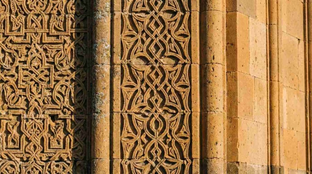
The Cathedral is the organizing presence — tall enough to be visible from the parking area, the pointed arches of its blind arcade crisp against the steppe sky, the stone the same warm honey color as the surrounding plateau. Up close, the carving detail is extraordinary: the ornamental blind arcading, the engaged column capitals, the geometric and vegetal interlace that covers the exterior surfaces in a program of decoration that rewards slow attention. Inside, the roofless nave is open to the sky. The pointed barrel vaults over the side aisles survive. Birds nest in the clerestory windows.
The Church of St. Gregory of the Abughamrents, the Seljuk caravanserai, the Zoroastrian temple ruins, the bridges over the gorge — the site requires three hours to cover in a way that does justice to what is here. The gorge is the southern boundary, the river sixty meters below, the Armenian hillside visible across it. It is worth sitting at the gorge edge for a while. The landscape across is not visually distinct from the landscape you are standing on. The difference is entirely political, entirely human, and entirely real.
Kars: The Base and the History
Kars, forty-five kilometers from Ani, was a significant Russian imperial garrison town from 1878 to 1920 and retains the grid plan and neoclassical architecture of that period. Orhan Pamuk used it as the setting for his novel Snow, and the city carries the quality of a place that has been geopolitically significant without ever having been comfortable. The food — kaz (dried goose), Kars gruyère-style cheese, lamb dishes from the eastern Anatolian tradition — is excellent and distinct from what you find in western Turkey. There are decent small hotels in the town center. The temperature in January is serious.
There is a particular kind of place that makes you aware of the scale of what history discards. Ani is that. The buildings are still there, structurally coherent, technically sophisticated — and utterly abandoned, for reasons that had nothing to do with the buildings and everything to do with who controlled the roads and the trade and the political geography. That is a category of loss that architecture can document but cannot explain. Standing in the nave of the Cathedral of Ani, open to the sky, you feel the gap between what was here and what remains. It’s worth making the trip for that feeling alone.
Sources
– UNESCO World Heritage Site, Ani (2016): whc.unesco.org/en/list/1518 – Turkish Ministry of Culture and Tourism, Ani archaeological site: ktb.gov.tr – Robert Edwards, academic work on Armenian architecture, The Fortifications of Armenian Cilicia (Dumbarton Oaks, 1987) – New York Times travel coverage of Ani: nytimes.com/travel