The Vanderbilt Connection Nobody Talks About: How Gilded Age Money Quietly Shaped Commack and Huntington Station’s Street Grid
Drive Commack Road north from the Long Island Expressway toward the old Huntington township line and pay attention to what happens to the roads that cross it. They don’t quite square up the way you’d expect. The intersections come in at angles. Some streets dead-end where they should connect; others jog slightly and resume. It looks like normal suburban patchwork — the kind of geographical stutter that happens when different developers plat their subdivisions in different decades without much coordination.
It isn’t. Some of that geometry has a specific origin, and that origin goes back more than a century, to a private road that a Vanderbilt built for sport and that Robert Moses eventually called a white elephant.
The Long Island Motor Parkway — also known as the Vanderbilt Parkway, still called “the motor parkway” in radio traffic reports decades after it closed — was the first limited-access highway ever built. Not the first in New York, not the first in the United States: the first in the world. William Kissam Vanderbilt II opened it in 1908 as a private toll road and racing course, running 45 miles from Fresh Meadows in Queens to Lake Ronkonkoma in Smithtown. By the time it closed in 1938, turned over to New York State in exchange for back taxes, it had drawn the first straight, high-speed right-of-way through the middle of Long Island — and that corridor, once drawn, didn’t disappear.
The Road That Built a Racing Fantasy
To understand what the Motor Parkway left behind, you need to know why Vanderbilt built it in the first place.
William K. Vanderbilt II was 26 years old when he created the Vanderbilt Cup Race in 1904 — America’s first major international road race, run on public roads in Nassau County. The crowds were enormous, sometimes estimated at 250,000 spectators. The danger was also enormous. When a spectator was killed by a race car in 1906 after fans broke through a barrier, Vanderbilt understood that running a high-speed race on shared public roads had a ceiling. He would have to build his own.
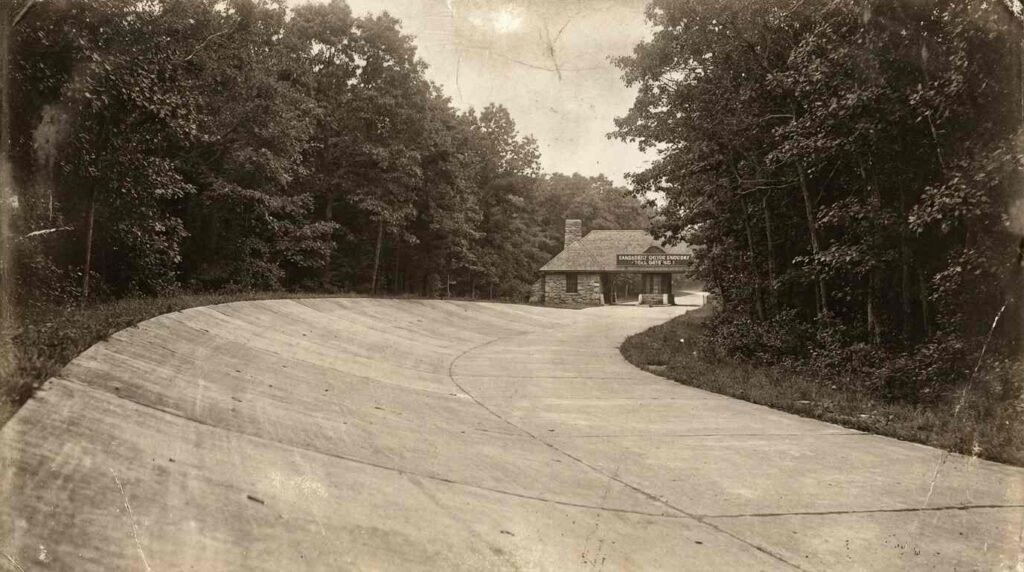
The result was a private company, a $6 million construction budget, a route negotiated parcel by parcel across central Long Island from Queens to the lake, and a road unlike anything that had existed before. The Long Island Motor Parkway used reinforced concrete — the first concrete highway in the United States. It used overpasses and bridges to eliminate grade-level intersections, 65 of them eventually, so that the road flowed without stop. It had banked turns, guardrails, and a controlled-access structure that would define limited-access highway design for the next century. The toll houses — twelve of them — were designed by John Russell Pope, the architect who later designed the Jefferson Memorial.
Races were held in 1908, 1909, and 1910, but an accident in 1910 that killed riding mechanics and injured others prompted the New York legislature to ban racing except on dedicated race tracks. The Motor Parkway pivoted to a toll road for pleasure driving, used primarily by the city’s wealthy heading to and from their Long Island estates. By the 1920s, 150,000 vehicles a year were using it. Then Moses built the Northern State Parkway — better designed, wider, and free — and the Motor Parkway’s economics collapsed. Vanderbilt reduced the toll to forty cents, then gave up entirely. Easter Sunday 1938, the gate closed.
Moses, never one for sentiment, called it “a white elephant for the past 20 years.”
What a 45-Mile Right-of-Way Leaves Behind
Here is the thing about a private road that gets built across 45 miles of Long Island farmland in 1908: it has to go somewhere. Vanderbilt’s route through what is now Mid-Island — through Commack, through the Huntington-area townships — was the product of years of parcel negotiation. Some landowners sold willingly. Others held out, and the road bent around them. The result was a corridor that wasn’t quite straight, wasn’t quite aligned with the township grids, but was continuous — a fixed line through the landscape that subsequent planning couldn’t simply ignore.
When the Motor Parkway closed in 1938, different sections had different fates. In Suffolk County, the easternmost section was kept as a public road — today it’s County Route 67, and the Hauppauge UFSD directions to its schools tell incoming visitors to “take the Long Island Expressway to Exit 57, make a left on Motor Parkway.” The name is still there on the signage, on the maps, in the GPS. In 1929, a spur was built at Commack connecting the parkway to Jericho Turnpike — today that’s Harned Road.
In Nassau County, the Long Island Power Authority used portions of the old right-of-way to run powerlines, which is why some of the old corridor shows up as utility easements on deed searches. In Queens, the roadbed became a bicycle path. Bridges that Vanderbilt built to carry the parkway over local roads were demolished in the 1950s and 1960s — but the grade changes they crossed, the underpasses, the angles — those left marks on the street geometry that followed.
How a Racing Road Became a Suburban Skeleton
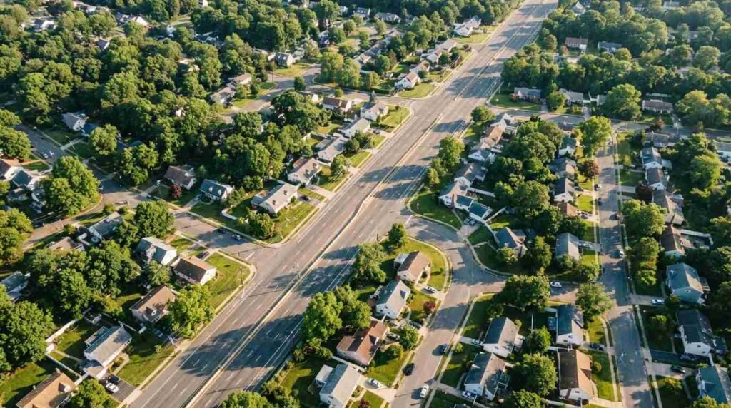
The connection between the Motor Parkway and the suburban street grid that followed it in the 1950s isn’t a direct one. Vanderbilt’s road didn’t automatically become the centerline of Levittown-style postwar development. What it did was establish something subtler: a right-of-way corridor that planners and developers had to work around.
When the Long Island population explosion hit in the late 1940s and 1950s — the mass suburbanization of Mid-Island that turned farmland into residential blocks at extraordinary speed — the road infrastructure that already existed shaped where new streets could go. Where the Motor Parkway’s right-of-way survived as a public road, as in the Hauppauge section now called County Route 67, that road became a spine that new subdivision streets connected to. Where it survived as a utility easement or a grade change, it created a constraint — a line that development had to sew itself around rather than through.
The Commack spur to Jericho Turnpike that became Harned Road is a direct example: that 2.1-mile connection, built in 1929, provided an arterial linkage between the Motor Parkway corridor and one of Mid-Island’s main east-west roads, and subsequent development in that area followed the access pattern it created.
What This Means for Buyers and Sellers Today
I find myself thinking about history most when it explains something I can see on a map. When I’m looking at a property near the old Motor Parkway corridor — which in Mid-Island terms means the Veterans Memorial Highway area, parts of Commack, and the Hauppauge access roads — and I notice an unusual lot configuration, an intersection that doesn’t square up, a parcel boundary that cuts across what should be a grid, some of that traces back to 1908.
That’s not just a trivia point. Here’s why it matters practically:
Deed searches in the old Motor Parkway corridor sometimes surface easements that aren’t fully understood by the current owner. Utility companies acquired right-of-way through former parkway sections, and those easements — which limit how land can be used — can still be attached to parcels that have changed hands many times since. If you’re buying land or considering development potential near the old corridor, understanding what’s in the chain of title matters.
Lot shapes in areas that developed around the old corridor tend to be irregular. When developers were platting subdivisions around a pre-existing road or easement, they often created odd-angled lots, split frontages, and non-standard lot depths to absorb the constraint. Those irregularities can affect everything from setbacks to expansion potential.
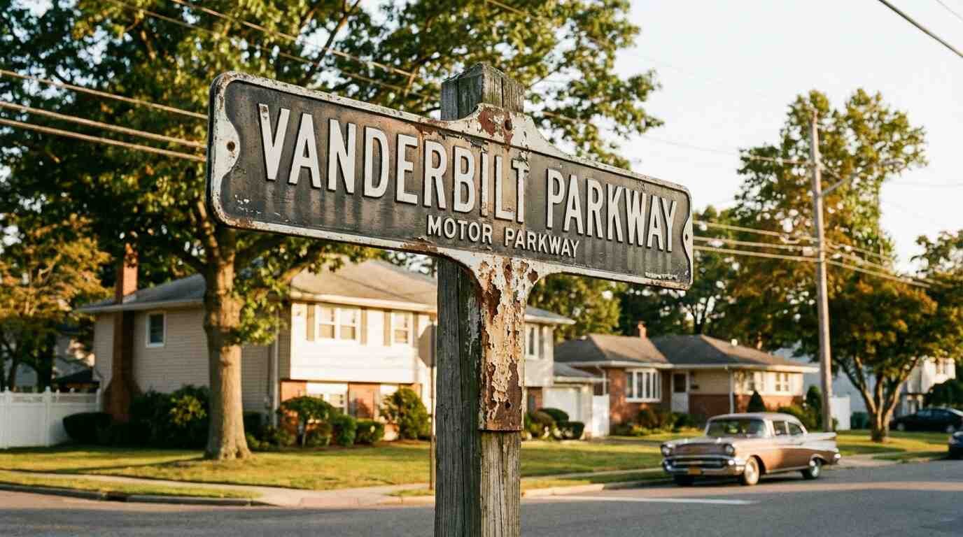
The road names are still there. If you’re doing neighborhood research and you see “Motor Parkway” or “Vanderbilt Parkway” in the address, you’re on an actual surviving section of the original road. That’s infrastructure that was built to a higher engineering standard than the county roads of its era, with reinforced concrete that demolition crews in the 1960s reportedly found remarkable for its durability.
A Long Island Story in Miniature
What the Motor Parkway’s afterlife actually illustrates is something I’ve come to think of as Long Island’s layered geography. The island is old enough, and has been transformed often enough, that almost every landscape feature has a prior use embedded in it. The duck farm became the subdivision. The estate became the school. The private racing road became the suburban spine.
Understanding those layers doesn’t just make you a more interesting person to have at a dinner party. It makes you a better buyer — someone who knows why a street turns where it turns, why a lot is shaped the way it is, why a block has the particular character it has. The Vanderbilt Motor Parkway is one of the cleaner examples: a road built for sport, by money that had no idea it was drawing the future, that became infrastructure the region couldn’t un-draw.
We’re still driving around on its ghost.
You Might Also Like
- The Landlord Nobody Remembers: How the Vanderbilt Estate Breakup Shaped Modern Centerport
- The Stroad That Ate Jericho Turnpike: How One Road Fragmented Five North Shore Communities
- Building the Moon Buggy in Bethpage
Sources
- Wikipedia — Long Island Motor Parkway
- Vanderbilt Cup Races — The Long Island Motor Parkway
- William G. Pomeroy Foundation — L.I. Motor Parkway historical marker
- NYC Parks — Motor Parkway History
- Forgotten New York — Long Island Motor Parkway
- Dix Hills Melville History — Long Island Motor Parkway
- New York Heritage — Long Island Motor Parkway Collection
- Historical Marker Database — Long Island Motor Parkway marker, Dix Hills