The Stony Brook University Hospital Site Before the Hospital: Reading the Archaeological Investigations That Preceded One of Long Island’s Largest Medical Complex Expansions
The campus of Stony Brook University Hospital is not, at first glance, a landscape that invites historical attention. The architecture is functional to a fault. The parking structures, the clinical buildings, the loading docks and utility corridors that constitute the working infrastructure of a major academic medical center — none of it presents itself as a place with a past. The landscaping is maintenance-grade. The ground has been moved, compacted, paved, and built over in successive waves of campus expansion.
Before all of that, archaeologists went in.
Stony Brook University, as a State University of New York institution receiving federal funding, operates under the requirements of Section 106 of the National Historic Preservation Act. That law mandates federal agencies and federally funded projects to identify historic properties — including archaeological sites — that may be affected by their undertakings, and to consult with the State Historic Preservation Office before proceeding. In practice, this means that every significant campus expansion at Stony Brook University — every new building, every infrastructure corridor, every major site modification — has been preceded by archaeological survey.
The reports generated by those surveys are public records, filed with SHPO and available through the Advisory Council on Historic Preservation’s consultation documentation process. They are also, as far as I can determine, among the least-read documents about what this land looked like before the university arrived.
The Pre-University Landscape
The campus of Stony Brook University occupies land that, prior to the university’s establishment in 1957 and its relocation to the current site, was primarily second-growth woodland and agricultural land on the sandy glacial outwash plain of central Brookhaven Town. The documentary record for this landscape — colonial and post-colonial land ownership records, 19th-century agricultural surveys, early 20th-century land use maps — is available through the county clerk records and the published historical scholarship.
But the land use that preceded the European settlement of this area is not recoverable from the documentary record. It is recoverable from the subsurface, and the Section 106 surveys have been recovering it, survey area by survey area, as the campus has expanded.
Published reports by the New York State Museum on Brookhaven Town pre-contact archaeology establish the regional context: this area falls within the documented territory of the Setalcott people, and the sandy, well-drained soils of the outwash plain were a preferred substrate for certain types of Algonquian land use — particularly the warm-season habitation sites and resource processing locations that left thin but characteristic deposits of fire-cracked rock, lithic debitage, and ceramic material.
The Section 106 surveys at Stony Brook University have documented exactly this type of deposit in multiple areas across the campus. The SHPO site file records for the Stony Brook University campus contain Phase I and Phase II archaeological survey results that identify pre-contact site locations distributed across the campus landscape — a spatial pattern consistent with the predictive models for Setalcott land use in this area.
The 18th-Century Farmstead Layer
Between the Setalcott occupation and the university’s arrival, the land that is now the Stony Brook University campus was agricultural. The 18th-century farmstead deposits documented in the Section 106 surveys are in some ways the richest and most detailed layer in the campus’s archaeological stratigraphy, because farmsteads leave comprehensive material signatures: structural remains (cellar holes, well shafts, privy pits), ceramic and glass assemblages from domestic life, faunal remains from the household food economy, and the agricultural soil modifications — plowzone deposits, drainage features, manure spreads — that record the farming operation over time.
The SUNY Stony Brook facilities planning environmental review records and the Section 106 consultation documentation contain descriptions of farmstead-related deposits encountered during pre-construction survey. The specific locations of these deposits are mapped in the survey reports, and the distribution of farmstead sites across the campus landscape tracks the documented colonial and post-colonial land ownership pattern in the county clerk records.
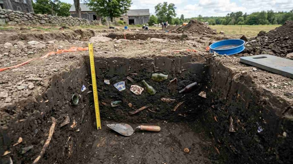
Privy pits are a particularly informative deposit type. A privy pit — the cesspit associated with an 18th or 19th-century outdoor toilet — accumulates an extraordinary variety of material in anaerobic conditions that preserve organic as well as inorganic remains. Food remains, clothing fragments, personal objects that slipped through the seat, the ceramic and glass vessels that were disposed of when they broke — a privy pit is an accidental time capsule of domestic life. The privy pits documented in the Stony Brook University Section 106 surveys represent, in each case, a concentrated deposit of 18th or 19th-century farmstead life preserved in conditions that the subsequent construction activity, in capping them with fill and impervious surface, has actually maintained.
The Section 106 Process as Archaeological Opportunity
The relationship between development pressure and archaeological discovery is not simply antagonistic. Section 106 has produced, over its decades of operation, a substantial accumulation of subsurface data about Long Island’s pre-university, pre-suburban, and pre-colonial landscapes that would not otherwise exist. The surveys are not conducted for their own sake — they are conducted to identify archaeological properties that might be affected by specific undertakings, and to find ways to avoid or mitigate those effects. But the data they generate is a genuine contribution to the archaeological record.
At Stony Brook University, the cumulative result of decades of campus expansion surveys is a campus-wide archaeological site inventory that provides a more detailed picture of the pre-university landscape than any other source. The Section 106 reports filed with SHPO document not just individual site locations but the spatial distribution of different site types across the campus — the clustering of pre-contact material in certain topographic zones, the farmstead deposits along historic road alignments, the absence of material in areas that the colonial survey evidence suggests were wetland.
That negative evidence is as informative as the positive. An area with no pre-contact archaeological material is telling you something about how the pre-contact landscape was used — or not used — at that location. A campus-wide survey that maps both presence and absence provides a landscape-scale picture of land use patterns over time.
What This Means for the Community
The Section 106 reports from Stony Brook University are not widely read. They are technical documents, written for regulatory compliance, filed in administrative systems and available to the public without being made accessible to the public in any meaningful sense. The residents of the Three Village area who live adjacent to the university campus — and whose property values are partly a function of the university’s presence — are generally unaware that an extensive archaeological record of the land they live near has been accumulating in SHPO files for decades.
I think that is worth noting, because the history documented in those files is not the university’s history. It is the history of the land — the Setalcott occupation, the colonial farmsteads, the 19th-century agricultural landscape — that predates the university by centuries and that the university’s expansion program has been, inadvertently, documenting.
The Three Village area’s real estate value is partly a product of its history, and the market recognizes that. The character that distinguishes the Three Village communities — the sense of place, the continuity with a particular vision of North Shore life — rests on a historical substrate that extends considerably deeper than the mid-20th century development that most people think of as the area’s founding moment.
The Section 106 reports are part of that substrate. Not a widely read part. But a real one.
Sources
- SHPO site file records for Stony Brook University campus surveys: https://www.nysparks.com/shpo/
- Section 106 consultation documentation — Advisory Council on Historic Preservation: https://www.achp.gov/section106
- New York State Museum — Brookhaven Town pre-contact archaeology: https://www.nysm.nysed.gov/research-collections/anthropology
- SUNY Stony Brook Facilities and Services — environmental planning: https://www.stonybrook.edu/facilities