The Clay Beneath Cold Spring Harbor: What Colonial-Era Pottery Sherds Found Along the Shoreline Reveal About Huntington’s Forgotten Industrial Past
There is a particular kind of attention you develop when you spend enough time along this harbor. Not the quick scan a buyer makes at a waterfront listing — taking in the dock, the sight lines, the light on the water. Something slower. You start to notice what the tide gives back.
I have walked the Cold Spring Harbor shoreline more times than I can count — with clients, alone, thinking through a neighborhood the way you think through a house, room by room. What I keep coming back to is this: the ground here remembers things that no one thought to write down. The deed records are meticulous. The whalers’ logs are extraordinary. But the people who worked this shore before the whaling era — the brick makers, the lime burners, the craftspeople who fired clay in kilns along these banks — left almost nothing in the documentary record. They left it in the soil instead.
What the Tide Is Turning Up
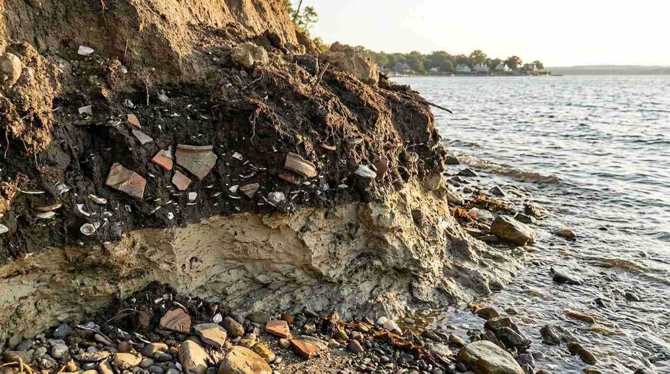
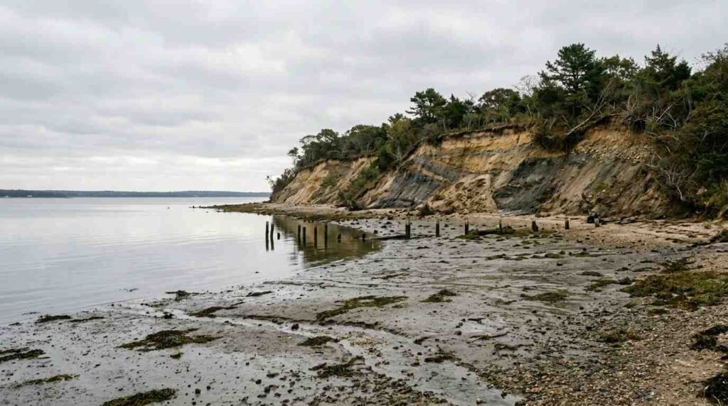
Erosion along Long Island’s north shore bluffs is not a new phenomenon, but it is an accelerating one. New York State’s SHPO database — the site inventory maintained by the State Historic Preservation Office — has flagged multiple locations along Cold Spring Harbor’s shoreline as areas where active erosion is exposing pre-contact and early colonial-era archaeological deposits. What that means in practical terms: every significant storm, every season of freeze-thaw, every high tide that bites a little further into the bluff face is also, inadvertently, excavating it.
What keeps falling out of those eroding cliff faces includes pottery sherds — fragments of fired clay vessels dating from the 17th and 18th centuries. To an untrained eye they look like rubble. To an archaeologist, they are primary documents.
The Cold Spring Harbor Whaling Museum holds material culture collections and archival records that extend well before the whaling era — into the period of shoreline industry that preceded it. Consultation with Huntington Town archaeologists on what these erosion-exposed deposits contain has produced a picture of the pre-whaling Cold Spring Harbor shoreline that looks nothing like the village visitors experience today.
Before the Whalers: The Working Shore
The dominant narrative of Cold Spring Harbor is maritime — the whaling industry that peaked in the 1840s and ’50s, the ships built and outfitted here, the captains whose houses still stand on the bluff above the village. That story is real and well-documented. But it displaced an earlier one.
Peer-reviewed work on Long Island’s colonial ceramic traditions, produced by archaeologists at the New York State Museum in Albany, identifies Cold Spring Harbor and the broader Huntington Township shoreline as a zone of early English colonial-era industry. The clay geology of this north shore terrain — laid down in glacial deposition — made it usable for a range of fired-earth industries: brick kilns, tile production, and the small-scale pottery making that supplied colonial households along the Sound.
Lime burning was equally significant. The oyster shell middens left by centuries of Matinecock use along this shoreline were not simply archaeological remnants — to colonial settlers, they were raw material. Shell middens were harvested and burned in coastal kilns to produce lime for mortar. The lime burning operations that operated along this shoreline in the 17th and early 18th centuries left physical traces: kiln sites, fuel ash deposits, and the ceramic fragments associated with the workers who operated them.
These were not prosperous people. They were craftspeople and day laborers operating in the interstice between the agricultural inland and the maritime economy developing on the water. They signed no contracts that survive. They appear in no ledgers that have been recovered. The SHPO site inventory is one of the few places where their presence is formally acknowledged — and it acknowledges them through what they left in the ground.
Reading a Sherd
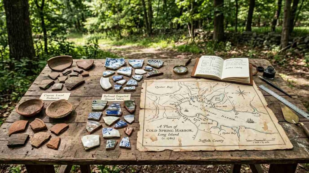
A pottery sherd tells you more than you might expect. The clay body — its mineral composition, its firing temperature, its texture — indicates where it was made. A coarse, sandy local ware fired at low temperature is almost certainly a product of north shore clay, made close to where it was found. A refined, high-fired redware with a lead glaze is almost certainly an import from the Connecticut River valley potteries that supplied Long Island households through the 17th and 18th centuries.
The distinction matters. Locally made ceramics indicate production. Imported ceramics indicate consumption and trade. A shoreline deposit containing both tells you something about how this particular stretch of the harbor functioned: as a place where goods were made and a place where goods came ashore.
The sherds turning up along Cold Spring Harbor’s eroding bluffs — documented in Huntington Town landmark records and flagged through SHPO consultation — include both. Local coarsewares associated with small-scale production. Imported wares associated with a household economy that was participating in the broader Long Island Sound trading network. Together, they sketch the outline of a working community that left no other written trace.
What the Whaling Era Covered
Here is the thing about a harbor that becomes successful: it reinvents itself. The infrastructure of the whaling era — the try-works, the cooperages, the chandleries, the expanded dock facilities — was built on top of what came before. Shoreline industry doesn’t leave deep deposits. It leaves thin, intermittent scatters of material that are easily disturbed, easily buried under later activity, easily erased by the next economic chapter.
What erosion is now exposing along Cold Spring Harbor’s bluff faces is, in part, what the whaling era buried. The pre-industrial shoreline is re-emerging from underneath the 19th century, fragment by fragment, as the bluffs continue to retreat.
The Cold Spring Harbor Whaling Museum’s archival collections contain records that reach back before the whaling period — land grant documents, early estate inventories, shoreline use records — that provide context for interpreting what the eroding bluffs are yielding. The museum is not, strictly speaking, an archaeological institution. But its collections document the historical matrix within which these material finds make sense.
What a Buyer Should Know
I bring up the archaeology not as a curiosity but because it speaks to something I think about constantly in this market: what a place carries in its ground, and what that means for the people who own it.
Properties along Cold Spring Harbor’s shoreline sit within areas designated as archaeologically sensitive by SHPO. That designation has real implications. Any ground disturbance — foundation work, dock construction, seawall repair, landscaping that involves significant excavation — may trigger a consultation requirement under New York State’s environmental review process. That’s not a barrier to ownership. It is, if anything, a layer of protection for what makes this harbor distinctive.
The bluff properties I’ve shown along this shoreline are among the most remarkable on the North Shore — not just for their sight lines but for the depth of history beneath them. The pottery sherds in the eroding bank below your dock are not an inconvenience. They are a record of who worked this water before the deeds were written.
That, to me, is worth understanding before you buy.
Sources
- Cold Spring Harbor Whaling Museum collections and archives: https://www.cshwhalingmuseum.org
- New York State Historic Preservation Office (SHPO) site inventory: https://www.nysparks.com/shpo/
- Huntington Town landmark records: https://www.huntingtonny.gov/landmarks
- New York State Museum — Long Island archaeology publications: https://www.nysm.nysed.gov